

Something significant is stirring beneath the surface of the Pacific Ocean, and scientists are paying close attention. El Niño, a climate phenomenon related to the warming of sea surface temperatures in the central-east equatorial Pacific, is set to return in 2026, throwing weather patterns worldwide out of whack, scientists have warned. The timing could hardly be more consequential. 2024 went down as the hottest year on record due to a combination of long-term human-caused climate change and a strong El Niño weather pattern. Now, forecasters say the stage is being set for a potentially dramatic sequel.
2024 was the hottest year on record, breaking the previous record set in 2023 and pushing the world over a critical climate threshold. Last year was 1.6 degrees hotter than the period before humans began burning large amounts of fossil fuels, according to Copernicus. It makes 2024 the first calendar year to breach the 1.5-degree limit countries agreed to avoid under the Paris climate agreement in 2015. Against that backdrop, the prospect of a new El Niño arriving is generating serious alarm across the scientific community.
NOAA Issues Formal El Niño Watch for 2026
The National Oceanic and Atmospheric Administration issued an El Niño watch, meaning conditions are favorable for it to develop during the next six months. This is not a vague warning. In a Thursday update, the National Weather Service Climate Prediction Center said that a shift from La Niña to ENSO-neutral is expected within the next month, with ENSO-neutral conditions favored through May to July 2026 at a 55 percent chance. By June to August 2026, El Niño is expected to develop at a 62 percent chance and persist through at least the end of 2026.
According to an advisory issued by the National Oceanic and Atmospheric Administration, El Niño is likely to form during the summer months and persist through the end of 2026 and potentially longer, with a 1-in-3 chance of becoming “strong” in the winter months. It marks a notable revision upwards from previous forecasts that suggested a modest El Niño might develop. Outlooks from NOAA, Australia’s Bureau of Meteorology, and other groups all show the same general scenario, with varying degrees of confidence and slight differences in timing.
The Mechanics Behind the Warming Pacific

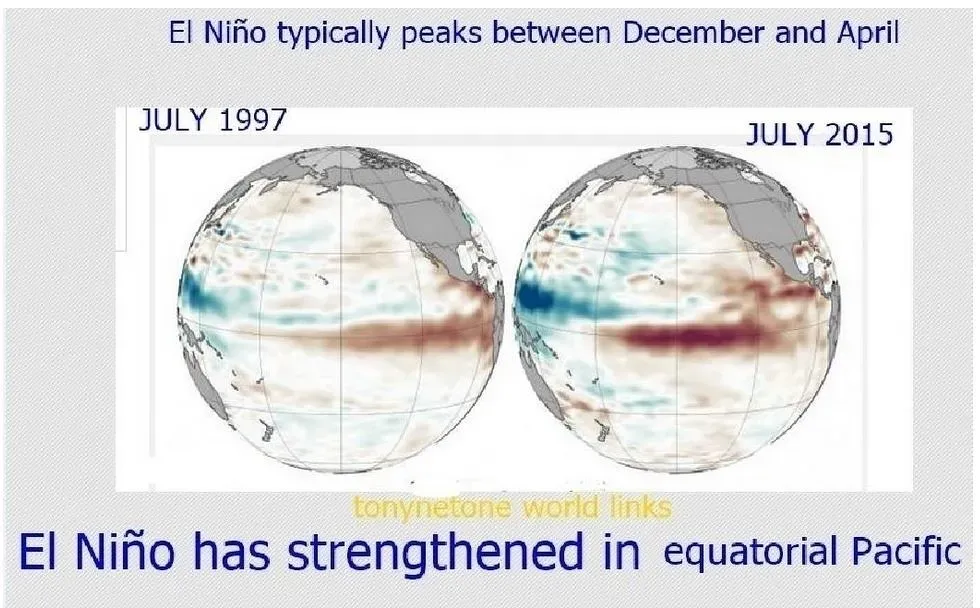
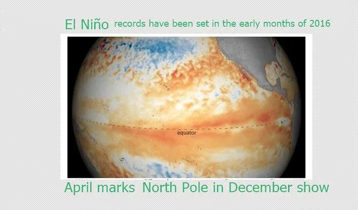
El Niño is characterized by unusually warm waters along the equatorial tropical Pacific Ocean, and a series of shifts in winds and precipitation patterns in the atmosphere. Those shifts are significant enough to affect weather around the world. The process that drives this phenomenon is well understood. El Niño occurs when trade winds weaken, allowing vast volumes of warm ocean water to move from the Eastern Pacific toward the Americas. What makes 2026 stand out is the speed at which conditions are evolving.
NOAA reported that the equatorial subsurface temperature index has been climbing, with above-average temperatures strengthening at depth across the Pacific. Forecasters said weakening trade winds are expected to allow that subsurface heat to surface and spread, conditions that typically precede a significant El Niño. This upcoming event is driven by powerful westerly wind bursts and a massive oceanic Kelvin wave currently surfacing in the eastern Pacific. Such an intense warming of the tropical Pacific can fundamentally alter the global jet stream and trigger a domino effect that extends across North America, Europe, and the rest of the globe.
Could a “Super El Niño” Be on the Horizon?

The planet may experience a strong or even a super El Niño later this year, one that could rival the strongest ones in history, according to new climate data recently released by the European Center for Medium-Range Weather Forecasts. That would be a rare and consequential escalation. During these relatively rare super El Niño events, happening once every 10 to 15 years on average, the effects may be stronger, more persistent and more widespread. That’s because sea temperatures in that key region of the Pacific Ocean warm more than 2 degrees Celsius above average, leading to a profound atmospheric response.
AccuWeather estimates there is a 15 percent chance of a super El Niño forming by the end of the Atlantic hurricane season in November. If confirmed, it would be only the third super El Niño in the past 30 years. Meanwhile, NOAA’s Climate Prediction Center gives a 1-in-3 chance of a strong El Niño emerging between October and December but describes the potential strength as “very uncertain.” “Even though the evidence is still early, this could be a very significant event in 2026 and lingering into 2027,” says Daniel Swain, climate scientist with the University of California Agriculture and Natural Resources.
What a New Record Heat Year Could Mean for 2027
The hottest years on record generally occur in years when El Niño is active, because El Niño occurs when the Eastern Pacific is hotter than usual. Scientists emphasize that El Niño does not act alone. El Niño is a natural cyclic fluctuation and is just one driver of such record-breaking heat. Human-caused global warming from burning fossil fuels is the main reason that the planet is warming. The two forces combined create the conditions most likely to shatter temperature records.
“If a strong El Niño does develop, it’ll boost temperatures in 2026 a bit, but it will have a particularly large effect on temperatures in 2027 and put that year on track to probably be the warmest year on record after 2024,” says Zeke Hausfather, research scientist at Berkeley Earth and climate research lead at technology company Stripe. NOAA’s National Centers for Environmental Information said there is more than a 90 percent chance 2026 will rank among the five warmest years on record. La Niña did not stop 2025 from being the third hottest on record.
Regional Disruptions: Droughts, Floods, and Wildfires

The associated warming in the central and eastern tropical Pacific leads to increased temperatures and opposing weather patterns around the world, such as severe droughts in places like Australia and Southeast Asia and heavy floods in other parts. The United States faces its own distinct set of pressures. During El Niño, trade winds weaken, allowing warm ocean water to shift eastward toward the Americas. This warming nudges the Pacific jet stream south of its normal position. As a result, the northern U.S. and Canada often see warmer, drier conditions, while the Gulf Coast and Southeast are more likely to experience wetter-than-normal weather and a heightened flood risk.
A marine heat wave building near the West Coast, partly linked to El Niño’s development, could influence a hotter-than-average summer across the Western U.S., further increasing the wildfire risk amid ongoing drought. Tropical countries across South America, Africa, the Middle East, as well as India and Australia, will likely swelter under extreme heat and humidity, coinciding with a rise in tropical sea temperatures and drought in some areas. As climate scientist Daniel Swain puts it, El Niño means “more heat waves and tangibly warmer temperatures, but maybe the more important thing is what it means for everything else: more energy for storms, heavier downpours, more intensive droughts, more extreme wildfires.”
The Atlantic Hurricane Season and the Pacific Storm Shift

El Niño typically suppresses Atlantic hurricane activity by increasing wind shear, which disrupts storm development. It tends to increase activity in the central and eastern Pacific instead. That redistribution of storm energy is a defining feature of El Niño years, and forecasters are watching it closely. El Niño brings higher pressure to the Atlantic, stronger wind shear, and a more stable atmosphere, preventing storms from organizing and powering up into large systems.
El Niño offers limited protection, since it only takes one major storm making landfall to cause catastrophic damage, and climate change has caused temperatures in the Atlantic to soar, providing more fuel for storms that do form. El Niño’s influence can also shift where storms are more likely to form, with activity sometimes favored farther out over the Atlantic rather than closer to the U.S. coastline. Meanwhile, El Niño can have the opposite effect in the eastern Pacific, where hurricane activity often increases. Hawaii could encounter more tropical storms and hurricanes this year, fueled by a patch of warm water extending across the subtropical and tropical eastern Pacific, because of an El Niño-linked phenomenon called the Pacific Meridional Mode.
- El Niño 2026: NOAA Warns of Record Global Heat and Extreme Storm Shifts - March 22, 2026
- The 10 Most Influential Climate Policies Ever Proposed – By Experts Few People Recognize - March 22, 2026
- Experts Say Homebuyers Are Now Avoiding These 7 Storm-Prone States – A Concerning Climate Shift - March 21, 2026