

- Florida Facing One of Its Driest Periods in Decades as Drought Intensifies - March 30, 2026
- A Meteorologist Reveals 8 Warning Signs of Severe Weather Ahead - March 30, 2026
- 10 Things You’ll Notice About Regions Already Affected by Climate Change - March 30, 2026
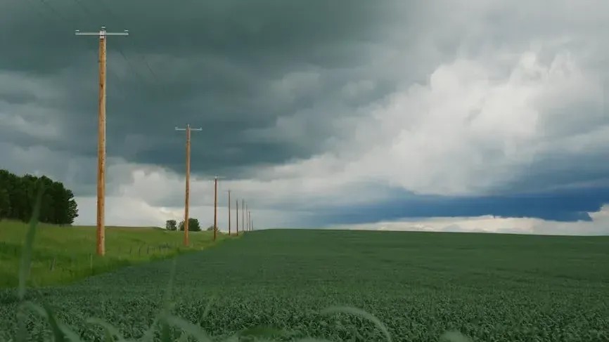
The sky darkened fast. The air went completely still. Then, without much warning at all, everything turned violent. If you’ve ever been caught off guard by a severe storm, you already know how terrifyingly fast the weather can shift. What most people don’t realize is that nature almost always gives signals before things get bad. The problem is, most of us simply don’t know what to look for.
A total of 605 extreme weather events occurred globally in 2024 alone, and roughly 824,500 people were displaced while more than 1.1 million were reportedly injured. Those numbers are staggering. During that same year, the United States alone experienced 27 weather and climate disasters each causing losses exceeding one billion dollars, ranking second highest for that category in any calendar year on record. Knowing the warning signs isn’t just interesting science. It’s the kind of knowledge that saves lives. Let’s dive in.
1. A Sudden, Sharp Drop in Barometric Pressure

Of all the invisible signals the atmosphere sends before a major storm, barometric pressure change is one of the most reliable. Think of it like the air holding its breath right before something terrible happens. Meteorologists recommend paying attention to barometric pressure trends over a 6 to 12 hour window, because a sharp drop almost always signals an incoming cold front and rapidly worsening conditions.
Atmospheric pressure plays a major role in weather changes. High pressure causes air to sink and warm, often leading to clear skies, while low pressure encourages air to rise and cool. As that air cools past the dew point, moisture condenses into clouds and, eventually, precipitation. That process can accelerate with alarming speed.
At sea level, standard atmospheric pressure sits at around 1,013 millibars, but extreme weather events like hurricanes or deep cold snaps can push readings below 980 millibars or above 1,040 millibars. Honestly, even a basic household barometer can alert you to dangerous trends well before the clouds arrive.
2. Rapidly Towering Cumulonimbus Clouds
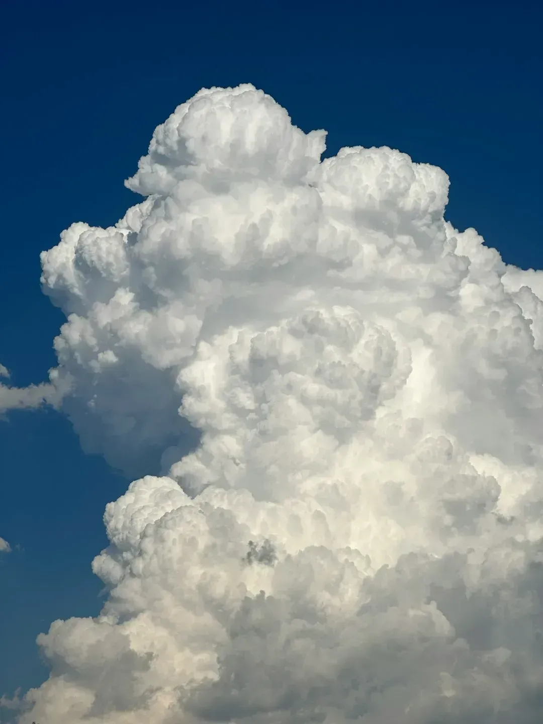
Most people see big, billowing clouds and think they look impressive. Meteorologists see something much more alarming. Three basic ingredients are required for a thunderstorm to form: moisture, rising unstable air, and a lifting mechanism to provide the initial nudge. When all three come together fast, the clouds don’t just grow. They explode upward.
Rapid vertical growth in cauliflower-looking cumulonimbus clouds indicates a mature thunderstorm that is likely producing heavy rain. Abundant moisture and instability due to cool air aloft and heating at the surface set the stage for their development, and a lifting mechanism such as a cold front can help trigger them. Heavy rain, frequent lightning, strong winds and hail can all be threats tied directly to cumulonimbus clouds.
The moisture inside these systems creates a temperature and cooling imbalance so clouds rise far faster than the surrounding air, and that quicker rising air creates lower surface pressure, which yields storms. All of that condensed moist air can cause the clouds to rapidly lift, creating the large, layered thunderhead clouds that signal a storm headed your way. If you see clouds going vertical in minutes rather than hours, take it seriously.
3. A Sudden, Eerie Calm Before the Storm
Here’s the thing about that strange, unsettling quiet that sometimes settles over everything right before a powerful storm. It isn’t your imagination, and it isn’t a good sign. Tornadoes often come after a thunderstorm when the sky appears deceptively calm and clear. Do not be fooled by this. It can merely indicate that a tornado is about to take shape.
A sudden calm that seems to precede the storm’s actual arrival is a recognized atmospheric warning cue. What’s happening physically is a temporary balancing act between inflow and outflow in the storm system. The air around you gets literally “sucked” toward the storm’s updraft before all chaos breaks loose.
I know it sounds almost counterintuitive. Calm is supposed to mean safe, right? Not here. The mature stage of a thunderstorm is the most likely time for hail, heavy rain, frequent lightning, strong winds, and tornadoes. That false quiet is often the atmospheric equivalent of a gun cocking before it fires. Get inside.
4. A Greenish or Sickly Yellow Sky
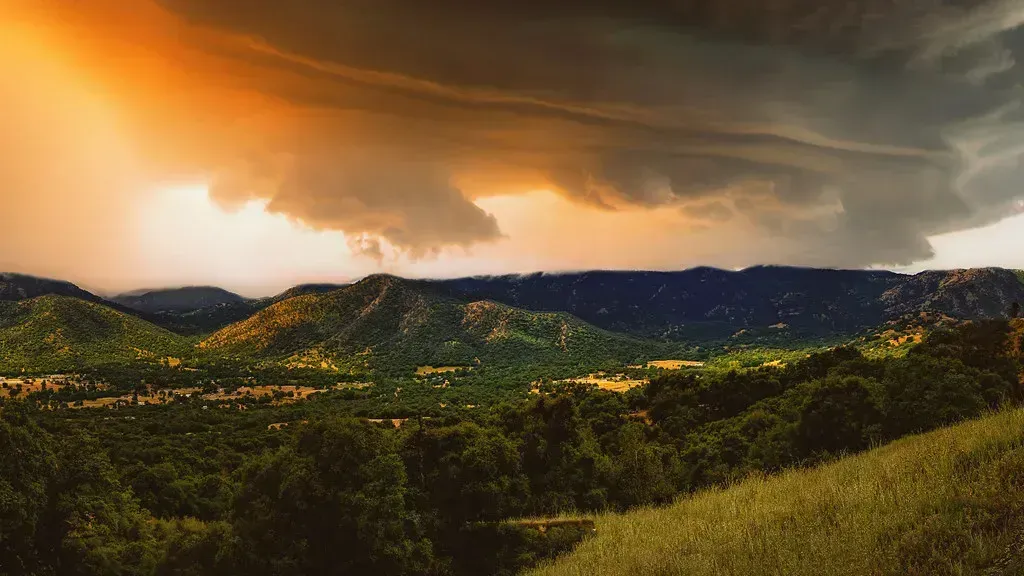
If the sky ever takes on a strange greenish or yellowish tint, stop what you’re doing. The sky often turns greenish as a result of light scattering by hail and moisture, the atmosphere darkens dramatically creating a foreboding appearance, and a yellowish or orange hue can appear due to dust and particles in the air. Each of these color changes carries a distinct meaning, and none of them are reassuring.
Such large thunderstorm clouds have the potential to produce severe weather such as tornadoes, large hail, frequent lightning and flash flooding, though they do not guarantee any of those outcomes. Still, the combination of a green sky with other warning signs on this list is genuinely alarming and demands immediate action.
The tornado count for 2024 was the second highest on record, with at least 1,735 confirmed tornadoes, and when looking at EF-2 or stronger tornadoes, 2024 was the most active year since the historic 2011 season. Recognizing the greenish sky as one early visual cue could genuinely be the difference between getting to shelter in time and not making it.
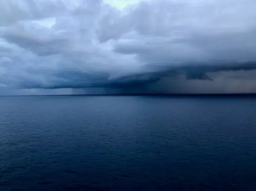
5. Rotating Wall Clouds and Shelf Clouds
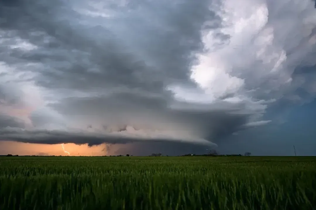
Not all dangerous clouds look dangerous at first glance. Shelf clouds and wall clouds are two formations that every person living in storm-prone regions should be able to identify on sight. A wall cloud is a cloud that lowers from a thunderstorm, forming when rapidly rising air causes lower pressure below the storm’s main updraft, and according to the National Weather Service, wall clouds can range from a fraction of a mile up to nearly 5 miles in diameter.
Storm chasers have communicated live warnings as rotating wall clouds presented serious potential danger near state border regions. Wall clouds that rotate are a warning sign of very violent thunderstorms, and they can be an indication that a tornado will touch down within minutes. Minutes. That’s how little time you could have.
The outer part of a shelf cloud is often smoother with a notable rising motion and a tiered look, while underneath it shows a turbulent, unsettled appearance. A shelf cloud should be seen as a harbinger of strong winds. The most destructive tornadoes occur from supercells, which are rotating thunderstorms with a well-defined radar circulation called a mesocyclone, and supercells can also produce damaging hail, severe non-tornadic winds, frequent lightning, and flash floods.
6. Surging Dew Points and Oppressive Humidity

Dew point is one of those weather variables that the general public largely ignores. That’s a mistake. Understanding how much moisture is in the air and how high the dew points are can indicate how strong and dangerous a thunderstorm is likely to become. It’s not just about comfort. It’s about fuel.
The Gulf of Mexico is a major driver of dew points in the United States, and meteorologists track dew points as they shift across the country because there’s a clear reason higher dew point temperatures are concentrated along the Southeast United States, with moisture ebbing and flowing from the Gulf while cold air pushes down from Canada. That clash of air masses is where the fireworks start.
Strong low level winds quickly move warm and moist air into a region, and what appear to be unimpressive temperature and dew point readings can change rapidly during the day as that process unfolds. Think of high dew points like pouring gasoline onto what might otherwise be a modest storm. The more moisture available, the more violent the outcome can be.
7. Frequent Lightning and Electrical Instability
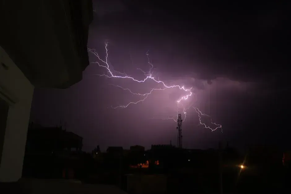
Lightning is not just a dramatic light show. It is one of the atmosphere’s most honest signals that something dangerous is building. Frequent and intense lightning, especially cloud-to-ground strikes, is another sign of a volatile thunderstorm, and while lightning doesn’t directly cause tornadoes, increased lightning activity can be associated with tornado formation.
Worldwide, there are an estimated 16 million thunderstorms each year, and at any given moment there are roughly 2,000 thunderstorms in progress. There are about 100,000 thunderstorms each year in the United States alone, and roughly one in ten of those reach severe levels. That’s an enormous number of potentially dangerous systems that could be producing exactly this kind of electrical warning sign.
NSSL researchers are currently testing a radar-based technique that spots areas of cold, dense air inside thunderstorms, which is a key signal for potential downbursts. These bursts of strong, damaging wind can happen very fast, especially during summer storms in the Southeast and Southern Plains. Frequent, rapid lightning accompanied by other signs on this list means it is time to act, not wait and watch.
8. Flash Flood Conditions and Rapid Water Rise
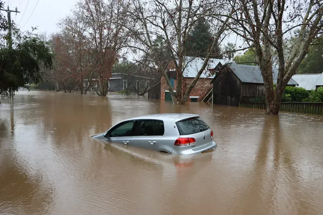
People consistently underestimate floods. It’s arguably the most deadly mistake in all of severe weather preparedness. Flash floods are a worldwide hazard and are the number one hazardous weather related killer in the United States, with NSSL researchers including hydrologists and hydrometeorologists working specifically to address the complicated problem of forecasting and warning for these events.
Intense droughts, floods, storms, heat waves and other climate-driven disasters claimed more than 11,500 lives and affected at least 148 million people worldwide in 2024, with floods among the deadliest disasters of that year, with 132 recorded flood events impacting approximately 43 million people. Those are numbers that demand serious attention.
Record-breaking global temperatures in 2024 translated directly into record-breaking downpours. From Kathmandu to Dubai to the Southern Appalachians, the year was marked by devastating floods, and of 16 major floods studied, 15 were driven by climate change-amplified rainfall. The reason reflects basic physics: a warmer atmosphere holds more moisture and leads to heavier downpours. When heavy rain is falling faster than the ground can absorb it, especially after a period of drought or on saturated soil, the window to react is often measured in single-digit minutes. Shortfalls in early warning and evacuation plans likely contributed to enormous death tolls in some of 2024’s worst flood events.
The numbers behind severe weather in 2024 and 2025 paint an urgent picture. Better weather forecasts and early warnings are considered the most effective tools available to protect people right now, yet around 40% of countries still lack full early warning system coverage, leaving millions exposed to preventable risks from extreme weather such as heatwaves, floods, storms, droughts and wildfires. Knowing these eight warning signs puts some of that protective power directly in your hands.
Nature rarely attacks without warning. The sky, the air, the clouds, and even a simple barometer all speak a language that meteorologists have spent decades learning to decode. The next time the air goes still, the clouds start to rotate, or the sky turns that strange shade of green, you’ll know exactly what it means. What would you do differently the next time you see these signs? Tell us in the comments.