
We are living through what climate scientists are now calling an inflection point. The last 11 years have been the hottest 11 years on record, according to international climate monitoring groups. That is not a typo. Eleven consecutive years. If that does not raise the hairs on the back of your neck, honestly, I am not sure what will.
The urgency to monitor, measure, and understand Earth’s changing climate has never been more pressing. Scientists around the world are deploying some truly jaw-dropping technologies to keep tabs on our planet, from orbit-skimming satellites to AI models that can sniff out a methane leak on the other side of the globe. Some of these tools are already operational. Others are just weeks away from going live. Let’s dive in.
1. The NISAR Satellite – A Radar Revolution From Space

If you want to understand what “transformational” looks like in climate science, look no further than NISAR. The NASA-ISRO Synthetic Aperture Radar satellite, a joint mission between NASA and the Indian Space Research Organisation, will scan nearly the entire globe twice every 12 days to measure changes in Earth’s ecosystems, cryosphere, and land surface. That kind of frequency and coverage is genuinely unprecedented.
NISAR launched from the Satish Dhawan Space Centre in India and will take 90 days to reach its science orbit. Once there, it will essentially give Earth scientists a constantly updated portrait of the planet’s most dynamic and vulnerable regions. Think of it like getting a brand new, hyper-detailed photograph of your entire house every single week, except the house is Earth.
NISAR is equipped with imaging tools that capture 25 to 100 square meters of ice surface as an individual pixel. Given that most satellites currently in orbit image sea ice at around 1 square kilometer per pixel, this is a major advancement. The NISAR data will also be used to help the ecological community understand nuanced changes in Earth’s carbon uptake by tracking sources and sinks of carbon.
2. AI-Powered Earth Observation Systems

Here is the thing about artificial intelligence and climate monitoring: the combination is quietly becoming one of the most powerful tools science has ever had. Innovative AI improvements in Earth observations can better identify and track human-caused environmental impacts and offer improved early warning alerts for planetary boundary overshoot. Such systems use AI-powered analytics to synthesize satellite, drone, and ground-based data for near-real-time results.
Google DeepMind’s GraphCast and Microsoft’s Aurora models have already outperformed operational benchmarks, while NVIDIA’s Earth-2 initiative is building an ecosystem for global-scale digital twins that simulate weather in near real time. That is not science fiction. That is happening right now in 2026. The practical applications of these AI systems reach far beyond weather forecasting.
Earth Observation refers to the growing ecosystem of satellites and aerial technologies that monitor what is happening on the planet’s surface. Thanks to cheaper satellite launches, advances in AI analytics, and growing demand from regulators and national security agencies, EO is quickly moving from a niche tool to essential infrastructure for monitoring resources, improving accountability, and tracking climate impacts. Satellite-based Earth observation combined with artificial intelligence is pioneering new methods to measure actions that help communities, ecosystems, and infrastructure adjust to current and future climate impacts.
3. The Copernicus CO2M Mission – Catching Carbon Criminals From Orbit

I know it sounds dramatic, but this technology is basically a lie-detector for carbon emissions. The Copernicus Anthropogenic Carbon Dioxide Monitoring mission, or CO2M, is a European Space Agency mission that will be the first to measure how much carbon dioxide is released into the atmosphere specifically through human activity. This distinction, natural versus human-made emissions, has long been one of the biggest challenges in climate science.
CO2M’s main goal is to help track greenhouse gas emitters and transparently assess whether nations are on track to meet the emissions targets set by the Paris Climate Change Agreement. CO2M’s instruments will measure key greenhouse gases, carbon dioxide and methane, and will also provide data on aerosol optical depth and nitrogen dioxide levels in the lower atmosphere. That is an impressive range of measurements from a single mission.
CO2M will make it possible to distinguish between natural and human-induced sources of carbon dioxide and methane, which is an immense challenge given the numerous sources with only a small fraction detectable in the overall atmosphere. The CO2M satellites will measure not only CO2 but also nitrogen dioxide, which is crucial because it allows man-made emissions to be distinguished from natural sources, since the combustion of coal, oil, and gas always produces NO2 in addition to CO2, in contrast to natural CO2 emissions from the biosphere.
4. MARS-S2L: The AI Model Hunting Methane Leaks Globally

Methane is a potent greenhouse gas responsible for roughly 30 percent of warming since the industrial era. Finding and stopping methane leaks is therefore one of the most impactful things scientists can do. Enter MARS-S2L, a machine learning model that is already doing exactly that, at a global scale, in real time.
During a sixteen-month period from January 2024 to April 2025, the model produced over 1,000 detections from 206 unique oil and gas production sources in 20 different countries, resulting in government and corporate stakeholder notifications. That is a stunning operational record for a relatively new AI system. It proves this is not just a lab experiment.
During the first 20 months of operational deployment, six successful mitigation cases of persistent methane emitters were recorded across Algeria, Libya, Kazakhstan, Yemen, Argentina, and Turkmenistan. Among these, two stand out: the elimination of a methane emitter that had been active for at least 25 years in Algeria, and the first mitigation of a new site discovered by the MARS-S2L model in Libya. A 25-year-old leak, finally caught and stopped by an algorithm. That is the power of this technology in action.
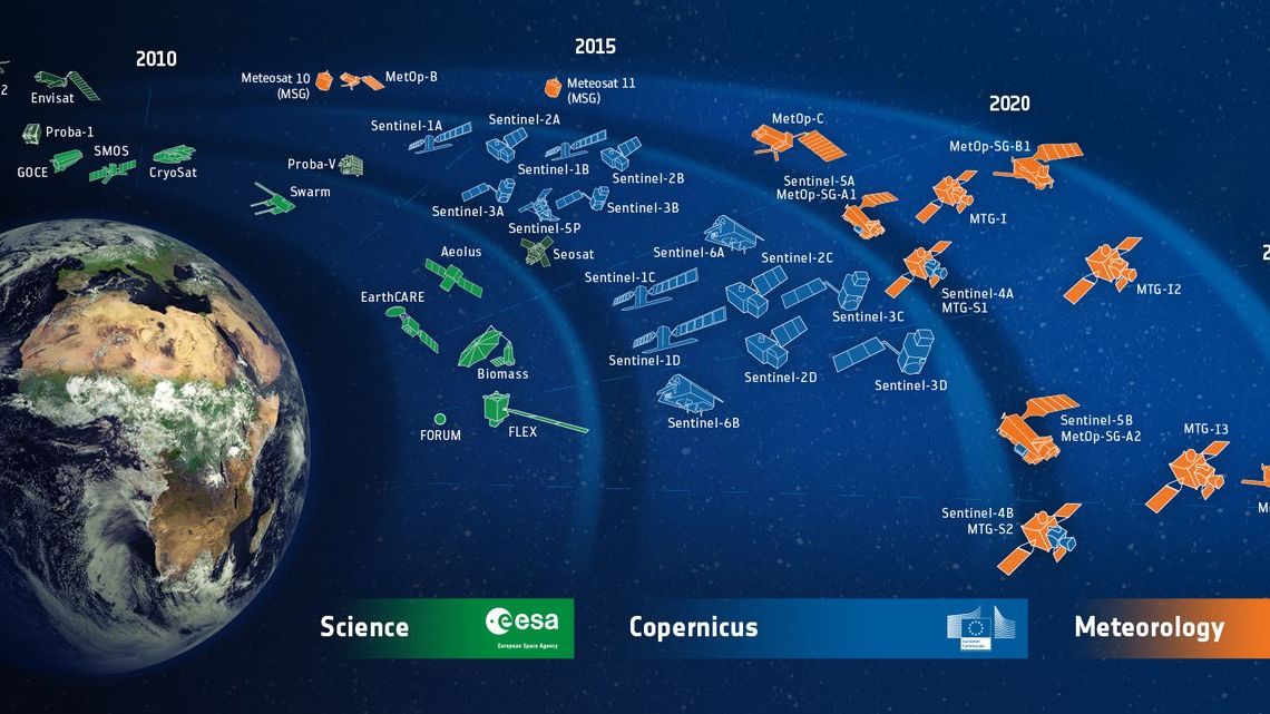
5. The Metop Second Generation Satellite Series
Weather forecasting and climate monitoring have always been close cousins, and the new Metop Second Generation satellites are pushing both forward simultaneously. The MetopSG-A1 satellite, launched in August 2025, carries six advanced instruments that allow measurements to be taken through the depth of the atmosphere to the surface. This kind of atmospheric profiling is essential for building accurate climate models.
The satellite provides a global view of the weather, completing one full orbit every 100 minutes. The finer resolution of data available enables more complex calculations to be run as part of weather forecast models and should ultimately enhance forecast accuracy. That improved accuracy matters for everything from disaster preparedness to long-range climate projections.
The first operational data from the satellite will be available in mid-2026. A second satellite, MetopSG-B1, will carry a further four complementary instruments and is due for launch later in 2026. So this is a story still in progress, and the coming months are going to be genuinely exciting for atmospheric scientists worldwide.
6. MicroCarb – Europe’s First CO2 Mapping Satellite

Less well-known than some of the headline missions, MicroCarb is quietly playing a crucial bridging role in global carbon monitoring. The CNES-led MicroCarb mission is Europe’s first satellite dedicated to mapping global carbon dioxide sources and sinks. Using a high-precision spectrometer, MicroCarb will help distinguish between natural absorption of CO2 and emissions from human activities.
Although independent from the Copernicus upcoming CO2M mission, MicroCarb will play a vital role as a Copernicus Contributing Mission by providing early observations to the Copernicus Atmosphere Monitoring Service. The expertise developed during MicroCarb’s commissioning and operational phases will directly contribute to the preparation of the CO2M satellites. Think of it as the test run that makes the bigger mission better.
Together, MicroCarb and Copernicus CO2M will form part of an expanding international satellite network focused on monitoring greenhouse gases, enabling scientists to better understand their sources, sinks, and atmospheric movement. It is hard to overstate how valuable an interconnected, international monitoring network is. No single satellite can do everything alone.
7. Copernicus Sentinel-4 – A Geostationary Eye on Air Quality

Here is a technology that almost snuck past the headlines without getting the attention it deserves. The Copernicus Sentinel-4 instrument, the Ultraviolet Visible Near-infrared spectrometer, was successfully placed in orbit on July 1, 2025, on board the Meteosat Third Generation Sounder 1 satellite. Unlike polar-orbiting satellites, a geostationary platform means it keeps a constant, persistent eye on a specific region.
This geostationary satellite will be the first ever European sounding satellite in geostationary orbit. It will complement the imager satellite and will provide regular information on the profiles of temperature and humidity through the atmosphere. Getting a continuous read on humidity and temperature throughout the full vertical column of atmosphere is something scientists have long wanted.
The session frameworks around this mission explore the contributions of different Copernicus satellites to monitoring the carbon, energy, and water cycles, as well as key operational contributions to greenhouse gas monitoring such as CO2M and other related missions. The Sentinel-4 data feeds directly into that larger ecosystem of climate intelligence, making every other monitoring system in this list a little bit smarter.
8. Drone-Based Methane Sensing With Laser Precision

Not every breakthrough in climate monitoring comes from space. Some of the most exciting developments are happening much closer to the ground, quite literally. Researchers have introduced a drone-based approach for measuring methane emissions using an open-path Tunable Diode Laser Absorption Spectroscopy sensor mounted parallel to the ground, rather than in the traditional nadir-pointing configuration. It is a subtle but important technical shift.
Scientists have developed and deployed an uncrewed aerial system that employs a fast and highly sensitive methane and ethane sensor along with an ultrasonic anemometer. The drone platform is capable of vertical profiling to 120 meters altitude and plume sampling across scales up to 1 kilometer. That is an impressive range for a device that can be deployed from the back of a pickup truck almost anywhere in the world.
The value here is ground-level precision. Satellites are great at spotting large-scale emission trends, but a drone can dart into a remote oil field or a landfill and pinpoint exactly where the leak is coming from. The combination of satellite-level surveillance and drone-level precision creates a monitoring system that leaves very few places to hide for large emitters. It’s a bit like having both a security camera and a flashlight in the same kit.
9. Satellite Altimetry for Sea Level and Ocean Monitoring

The oceans are where much of the evidence of climate change is written most clearly. The oceans continue to absorb about 90 percent of the heat added by climate change, and globally averaged sea surface temperatures are the warmest in the modern satellite and buoy record. Keeping close watch on these changes requires some of the most precise instruments humans have ever built.
Sentinel satellites carry state-of-the-art altimeters used to measure global sea-level height, wave height, and wind speed over the oceans. These satellite altimeters very precisely measure along-track sea surface height, the height of the ocean below the instruments as they orbit the Earth. The data produced by these altimeters feeds into global sea level records that track one of the defining consequences of a warming world.
Copernicus Sentinel-3 carries not only a Synthetic Aperture Radar Altimeter but also additional instruments that measure sea surface temperature and ocean colour. These data play an important role in better understanding marine phenomena such as marine heatwaves and algal blooms. With the addition of freshwater from melting glaciers and thermal expansion, globally averaged sea level rise has reached the highest level in the satellite record of sea level, which began in 1993. Those numbers are not abstract. They represent real threats to coastal cities everywhere.
10. Advanced Earth Observation Platforms for Flood and Hydrological Monitoring

Water is one of the climate system’s most dynamic variables, and monitoring it across the entire planet is a genuinely enormous challenge. New data systems are providing scientists with an unprecedented ability to measure key variables and inform decisions regarding agriculture and disaster response in a time of extreme climate risk, and to monitor and pinpoint ongoing deforestation drivers. Advanced Earth observation platforms are already being implemented.
The Copernicus satellite observation programme run by the European Space Agency can monitor floods anywhere in Europe, and the Early Warning for All initiative is very useful in isolated regions of Africa with little access to internet. This system can forecast flooding and landslides, manage irrigation for precision agriculture, and track human interaction with hydrological systems affected by the building of dams and irrigation infrastructure. The reach of this technology into underserved communities is one of its most important dimensions.
Groundwater is being depleted faster than in previous decades, as climate change disrupts aquifer recharge and rising socioeconomic demands increase extraction. The integration of AI and machine learning into groundwater exploration and water resources management has emerged as a transformative approach to addressing global water challenges, with applications in groundwater potential mapping, water quality prediction, and groundwater level forecasting. Nearly half of the world’s population is beginning to live in water-stressed areas, turning water from a boring utility into a boardroom-level risk. That shift, from an afterthought to a top-tier emergency, is exactly why this technology deserves a place on this list.
The Bigger Picture: Why These Technologies Matter Right Now

Taken together, these ten technologies represent something remarkable: the construction of a genuine, global climate nervous system. Each year, the world’s leading climate scientists evaluate the most critical evidence on how our planet is changing. Their assessments draw heavily on data from Earth-observing satellites, and the latest reports deliver stark warnings that the planet’s energy balance is drifting further out of alignment, ocean warming is accelerating, and the land’s capacity to absorb carbon is declining.
The stakes could not be higher. Monitoring programs including NOAA’s CO2 measurement at the Mauna Loa Observatory in Hawaii, NASA’s OCO-2 and OCO-3 satellites monitoring carbon dioxide from space, and the EPA’s Greenhouse Gas Reporting Program have faced disruption, which underscores just how fragile this global monitoring infrastructure can be when political winds shift.
As climate impacts intensify, adaptation technologies are emerging as one of climate tech’s fastest-growing segments, having grown dramatically to $5.5 billion in 2025, according to Net Zero Insights. The money is following the urgency. Scientists are building the tools, and the world is beginning to invest in them. Whether that investment comes fast enough is, honestly, still an open question. What do you think – is the technology outpacing our will to use it? Let us know in the comments.