


- Why Scientists Track Atmospheric Carbon With Giant Towers - October 7, 2025
- The Link Between Melting Ice and Rising Sea Levels Explained - October 6, 2025
- How Ocean Currents Help Regulate Global Climate - October 5, 2025
Deadly Earthquake Strikes Peru’s Capital Region
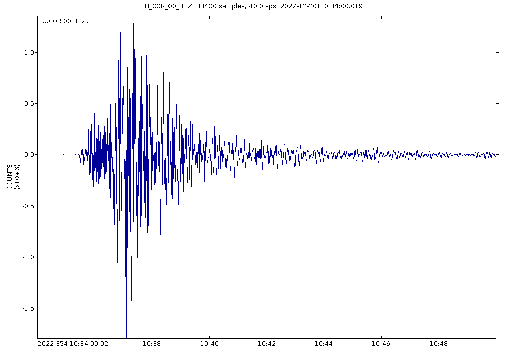
Sunday, June 15, 2025, will be remembered as a tragic day for Lima’s residents when a 6.1-magnitude earthquake struck Peru just before noon, with its epicenter located about 30 kilometers from Callao, near the capital Lima. The quake, which occurred at exactly 11:35 a.m. local time in the Pacific Ocean, brought the busy metropolis to a standstill as millions felt the ground shake beneath their feet. A man died in Lima when a wall collapsed onto his car, marking the first casualty of what turned out to be a deadly natural disaster. The seismic event created chaos across the city, with dust clouds billowing through streets as people rushed out of buildings seeking safety. A 36-year-old man died in northern Lima while “standing outside his vehicle waiting for a passenger” when a wall from the fourth floor of a building under construction detached and fell on his head. The tragedy serves as a stark reminder of how quickly natural disasters can transform ordinary moments into life-threatening situations.
Casualties and Infrastructure Damage Across Lima

The five people injured are being treated in hospitals, with authorities working around the clock to monitor their conditions and provide necessary medical care. The agency also reported damage to roads and educational centers, highlighting the widespread impact of the seismic event on critical infrastructure. The earthquake’s effects rippled through various parts of the metropolitan area, causing structural damage that will require extensive assessment and repairs. Footage shared by local media showed cars hit by falling debris, damaged houses and collapsed billboards. Peru’s National Emergency Management Center confirmed one fatality and five injuries, reporting an undetermined number of homes and roads with damage, as well as five health facilities affected. The scope of the destruction demonstrates how even moderate-magnitude earthquakes can have significant consequences in densely populated urban areas like Lima.
Immediate Response and Presidential Action

President Dina Boluarte is heading to Callao to monitor developments, demonstrating the government’s commitment to managing the crisis response effectively. Her immediate mobilization to the affected area shows the seriousness with which Peruvian authorities are treating this natural disaster incident. All of Lima’s districts felt the earthquake, according to Hernando Tavera, executive president of the Geophysical Institute of Peru, indicating the widespread nature of the seismic impact across the capital region. The earthquake caused significant disruptions to daily life, with local radio stations reporting that a professional football match at Lima’s Alberto Gallardo Stadium was paused for several minutes. A mass at Lima’s cathedral was also interrupted, after frightened worshippers fled the scene. These incidents illustrate how the earthquake affected both sporting events and religious gatherings, showcasing the pervasive nature of the natural disaster’s impact on community activities.
Scientific Analysis and Ring of Fire Context
The Peruvian presidency reported that the magnitude of the earthquake was higher than the USGS assessment, registering a 6.1 magnitude, highlighting the differences that sometimes occur between national and international seismic monitoring agencies. The epicenter was located 24 km WSW of Callao and 29 km SW of Lima, within the central Peruvian coastal zone, where urban density and infrastructure are among the highest in the country. About 90% of the world’s earthquakes, including most of its largest, occur within the Ring of Fire belt. Peru experiences frequent seismic activity, with at least 100 detectable earthquakes each year, as the South American country lies on the “Ring of Fire”, a path along the Pacific Ocean that is frequently struck by earthquakes and active volcanic activity. On average an earthquake will hit near Peru roughly every 16 hours, making this recent event part of a continuous pattern of seismic activity that defines the region’s geological reality.
Historical Context and Future Earthquake Risk
The deadliest earthquake on record in Peru remains the 1970 Ancash earthquake, which killed around 67,000 people, putting the current disaster into perspective while underscoring the ongoing seismic risks facing the nation. Statistically, earthquakes with a magnitude of 8 or more occur in Peru approximately every 15 years, while for quakes ≥ 7, there are around 2 years in between. The last major earthquake occurred in 2021 in the Amazon region, registering a magnitude of 7.5, and left 12 people injured, destroying more than 70 homes. Around 68,600 inhabitants have died in earthquakes since 1950, a sobering statistic that emphasizes the long-term human cost of living in one of the world’s most seismically active regions. Peru is located on the west coast of South America and is heavily affected by earthquakes as it is situated on an active subduction zone, where the oceanic Nazca plate collides with the continental South American plate. This geological reality means that Peru will continue to face earthquake risks as part of its natural environment, making earthquake preparedness and building safety crucial priorities for the nation’s future development.