


- Americans Are Avoiding These 6 Climate Risk Zones – Here’s Why - March 30, 2026
- AccuWeather Predicts 11–16 Named Storms for the 2026 Atlantic Hurricane Season - March 30, 2026
- The Weather “Avoid” List: 5 Situations Meteorologists Say to Stay Inside - March 29, 2026
Every year, the question comes earlier and earlier. Before summer even hints at arriving, meteorologists are already watching the Atlantic with a careful eye. The 2026 hurricane season has not even started, yet experts are already raising flags, running models, and debating what kind of storm threat the United States will face. And honestly, the picture this year is more complicated than a simple number can tell.
Less storms does not mean less danger. That is the central tension in AccuWeather’s freshly released outlook for 2026. There are quieter numbers on paper, but a set of underlying factors that could make this season every bit as punishing as recent, more active ones. So let’s dive in.
AccuWeather’s Official Numbers: What the Forecast Actually Says
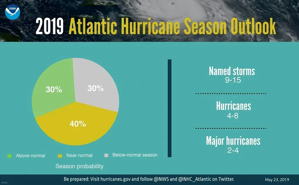
More than two months before the Atlantic hurricane season officially opens its doors on June 1, AccuWeather has already delivered its first major forecast for 2026. AccuWeather is predicting 11 to 16 named storms, including four to seven hurricanes and two to four major hurricanes, which are Category 3 or higher. That is the headline number, and at first glance it sounds like a relief.
For comparison, the historical average is 14 named storms, seven hurricanes, and three major hurricanes. So we are looking at a season that could fall anywhere from meaningfully below average to just about average, depending on how conditions evolve. The forecast calls for 11 to 16 named storms during the 2026 season, placing activity near or slightly below historical averages.
Forecasters also expect three to five direct impacts on the United States throughout the 2026 season, with El Niño forecast to develop and strengthen throughout the summer and autumn, likely translating to fewer storms during the second half of the hurricane season compared to the first half. That split matters more than most people realize.
El Niño: The Season’s Biggest Weather Wildcard

Here’s the thing about El Niño: it does not simply hit a switch and make hurricanes disappear. It creates conditions that make it harder for storms to organize and thrive. El Niño occurs when ocean temperatures near the equator of the eastern Pacific Ocean warm to at least 0.9 of a degree Fahrenheit above the long-term averages, and the warmer the water in this area of the Pacific, the greater the effect it will have on tropical activity worldwide. Typically, El Niño creates stronger upper-level winds across the Atlantic, making it harder for tropical storms to take shape.
Since the start of the satellite era in the 1960s, El Niño years have averaged about 10 named storms and five hurricanes. That is well below the historical average during La Niña years, which typically produce around 15 named storms and eight hurricanes. That context makes AccuWeather’s forecast range of 11 to 16 storms look somewhat busy, even for an El Niño year.
There is about a 15% chance that a “super El Niño” will develop if ocean temperatures near the equator of the eastern Pacific rise at least 2 degrees Celsius above long-term averages. If it does happen, it could sharply reduce storm activity in late October and November. A roughly one-in-seven chance. Not a certainty, but not negligible either.
The Rapid Intensification Threat: Fewer Storms, But Fiercer Ones
I think this is the part of the 2026 forecast that should genuinely concern people. Lower storm counts do not automatically mean lower risk. The ocean heat sitting beneath the surface of the Atlantic, Caribbean, and Gulf of Mexico this year is extraordinary. In 2026, water temperatures across the Gulf of Mexico, Caribbean Sea, and Atlantic Ocean are forecast to remain exceptionally warm, and importantly, this heat extends deep below the surface.
Despite lower activity expectations, AccuWeather Lead Hurricane Expert Alex DaSilva warned that exceptionally warm ocean waters extending deep below the surface provide additional fuel for rapid intensification. Think of it like this: the ocean is essentially pre-loading its punch. Fewer storms, but each one has a tank full of fuel.
In the North Atlantic, the number of storms that quickly intensified from Category 1 or weaker into a major hurricane has more than doubled in 2001 to 2020 compared to 1971 to 1990. That trend is not going away in 2026. That amount of energy packed into Gulf waters can not only create big hurricanes strong enough to resist wind shear, it also encourages rapid intensification like that seen by Hurricane Milton two years ago – a tropical storm one day, Hurricane Milton exploded into a Category 5 in just over 24 hours, with winds jumping from 80 mph to 175 mph in about 18 hours.
Lessons From 2025: When Fewer Storms Still Shocked the World
It’s worth stepping back and looking at last year before we assess what 2026 might bring. The 2025 Atlantic hurricane season delivered one of the most striking contrasts in modern meteorological history. Thirteen tropical cyclones formed, all of which intensified into named storms. Five storms strengthened into hurricanes, four of which became major hurricanes – the highest percentage ever observed in an Atlantic hurricane season.
Extraordinarily, three of 2025’s 13 named storms reached Category 5 strength: Erin, Humberto, and Melissa. That is a jaw-dropping stat. That was the second most on record for the Atlantic, trailing only 2005, which had four Category 5 hurricanes. No other season has had more than two.
No hurricanes made landfall in the United States this season, for the first time since 2015. So the U.S. got lucky, frankly. Hurricane Erin underwent rapid intensification and is tied for the fifth-fastest 24-hour increase in maximum sustained winds on record, from 75 mph to 160 mph. Erin also tied for the third-fastest 24-hour pressure drop in the Atlantic basin on record, dropping 83 millibars. The storms were ferocious. They just did not happen to track toward land.
Which Parts of the U.S. Face the Highest Risk in 2026

AccuWeather’s forecast is not just a raw storm count. It also points to where the greatest dangers are likely to concentrate geographically. The areas of the U.S. at greatest risk of direct impacts from a tropical storm or hurricane in 2026 are the northern and northeastern Gulf Coast and the Carolinas. That covers a lot of coastline and millions of people.
To make the landfall risk forecast, AccuWeather forecasters looked back at past years with weather patterns similar to what is expected this season. In years such as 2009, 2014, 2018 and 2023, tropical storms and hurricanes brought more impacts to these areas than to other parts of the Gulf and Atlantic coasts. Historical pattern-matching like this is one of the most useful tools forecasters have.
The risk of significant tropical impacts is lower along the Texas coast, but that does not mean the state is in the clear. In 2023, one of the only storms to make landfall in the U.S. was Tropical Storm Harold, which impacted southern Texas. Lower risk is not zero risk. That is a distinction worth driving home every single season.
The Bermuda High, Saharan Dust, and Other Hidden Shapers

El Niño gets most of the headlines, but it is far from the only force steering the 2026 season. El Niño will not be the only influence on tropical storms and hurricanes in 2026. Another factor is the position of the Bermuda High. AccuWeather’s DaSilva said it may sit a bit farther south and east again this year, similar to last season. That setup can allow more storms to curve away from the U.S., especially in the western Atlantic.
Forecasters are also watching for periods of dry Saharan dust and changes in the flow of tropical waves coming off Africa. Those factors could, at times, slow development in the main area where storms usually form across the Atlantic. Saharan dust acts almost like a natural suppressor, blanketing developing systems in dry air and making it harder for them to organize.
The early part of the hurricane season is when “homegrown development” is most frequent. This can happen if a storm or front that moves across North America stalls over the Gulf, western Caribbean, or western Atlantic Ocean. As it sits over warm water, it may eventually transform into a tropical depression, tropical storm, or even a hurricane. When storms develop so close to land, it means there is less time for coastal residents to prepare for potential impacts.
How 2026 Compares to Other Forecasts and Historical Benchmarks
AccuWeather was not the only group to weigh in early. On December 11, 2025, Tropical Storm Risk (TSR) released their first forecast for the season, expecting a near-normal season with 14 named storms, 7 hurricanes, 3 major hurricanes, and an Accumulated Cyclone Energy index of 125 units, close to the thirty-year average. The general direction of multiple forecasts is consistent: near or slightly below normal activity.
The last time there was an El Niño during the Atlantic hurricane season was 2023, which was busier than normal with 20 named storms, above the historical average of 14. That is an important reminder that El Niño does not guarantee a quiet season. Warm Atlantic water can push back against El Niño’s suppressive effects, something that played out vividly just three years ago.
Although AccuWeather is predicting a near- to below-average number of tropical storms and hurricanes this year, 2026 could still be fairly active compared to other El Niño years. Since the start of the satellite era in the 1960s, El Niño years have averaged about 10 named storms and five hurricanes. That is well below the historical average during La Niña years, which typically produce around 15 named storms and eight hurricanes.
The Bottom Line: Numbers Mean Nothing Without Preparation

Let’s be real for a moment. The number of named storms in any given season is, in many ways, a secondary story. What matters is where those storms go. History has proved this lesson again and again. The 1992 season produced only seven named storms but included Hurricane Andrew, one of the most destructive U.S. hurricanes on record. Seven storms, one catastrophe.
From 1980 to 2023, 177 landfalling Atlantic tropical cyclones rapidly intensified. The vast majority – roughly seven in ten – of the 63 total billion-dollar tropical cyclones in the U.S. since 1980 rapidly intensified before landfall. That is a staggering figure, and it underlines why ocean heat content matters so much more than storm counts.
Though the 2026 season is currently projected to fall slightly below the 10-year average for total storms, meteorologists stress that risk levels remain significant, especially for states frequently affected by severe weather systems. Florida, Alabama, Mississippi, Louisiana and Virginia are among the areas that could experience the strongest impacts if storms track toward land. The coast does not take a year off, and neither should preparedness. What would it take for you to feel truly ready before June 1? That is the question worth sitting with this spring.