

- 11 Historic Wildfires That Changed Fire Management Data Reveals - October 4, 2025
- The 1883 Krakatoa Event And Its Global Weather Effects Records Show - October 2, 2025
- How Scientists Use Climate Models To Forecast The Future - October 2, 2025
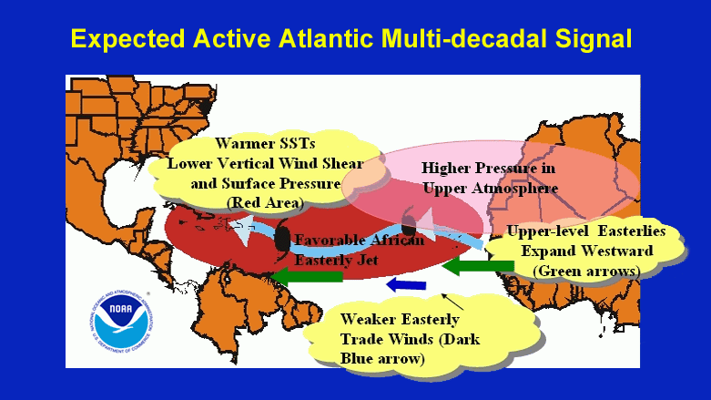
Understanding the Climate Cycle: The Atlantic Multidecadal Oscillation (AMO)
The Atlantic Multidecadal Oscillation (AMO) is a powerful climate cycle known to influence significant weather events and temperature trends across the North Atlantic region. Scientists define the AMO as a recurring pattern of long-term sea surface temperature changes, with each cycle lasting between 60 and 80 years. In 2023, researchers published findings in the journal *Nature Climate Change* that emphasized the AMO’s role in shaping rainfall, drought, and hurricane activity. The last major warm phase started around 1995, with expert consensus suggesting the likelihood of a transition to a cooler phase by 2025. The National Oceanic and Atmospheric Administration (NOAA) continues to monitor the AMO closely, highlighting its potential to disrupt established climate trends and impact international climate policy. Recent discussions among climate scientists have urged governments to factor in the AMO’s influence as they respond to increasingly unpredictable weather patterns. The AMO remains a critical, yet often overlooked, component in the broader discussion of climate variability.
Historical Context: AMO Phases and Their Impact

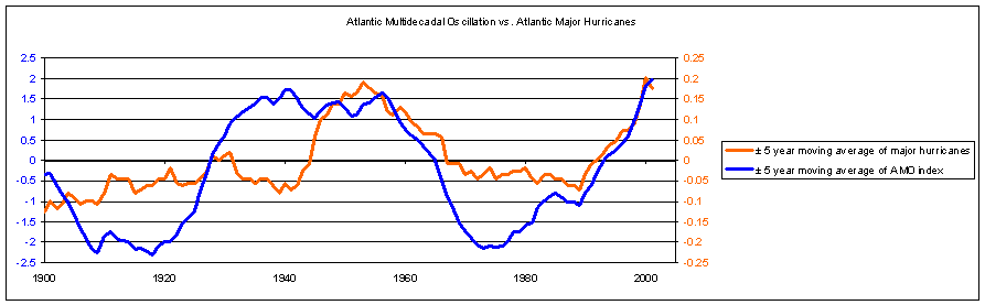
Historical records show the AMO’s dramatic influence on weather and climate events throughout the 20th century. For example, the warm phase from 1930 to 1960 brought heightened hurricane activity, increased rainfall in some parts of the United States, and milder winters in the Northeast. The subsequent cool phase from 1960 to 1995 was marked by notably fewer hurricanes and shifts in rainfall patterns that impacted agriculture and water management. The current warm phase, starting in the late 1990s, saw a stark rise in major hurricanes, including the devastating hurricane seasons of 2005 and 2020. According to a 2024 World Meteorological Organization (WMO) report, this warm phase also aligns with some of the hottest years recorded globally. Researchers analyzing these cycles stress that the transition to a cooler phase could bring both relief and new challenges, depending on the region and sector affected. Understanding these cycles helps policymakers and scientists anticipate what might come next as 2025 approaches.
Current Observations: Signs of Transition

Over the past year, satellite and buoy data have revealed subtle but consistent cooling in North Atlantic sea surface temperatures. In early 2024, the University of Miami released a study documenting a 0.3°C decline in average temperatures since 2022, a sign that the AMO could be shifting toward a cool phase. This cooling trend raises critical questions for meteorologists, as even small temperature changes can disrupt global weather systems. Experts note that such transitions are often accompanied by shifts in precipitation, with some regions experiencing drought while others face increased flooding. Recent observations in the North Atlantic have already shown changing ocean currents and altered wind patterns, both linked to the AMO’s behavior. While the cooling might temper hurricane frequency, it could also introduce new extremes, such as unexpected cold snaps or heatwaves elsewhere. The climate science community is watching these indicators closely, recognizing that the next two years may provide decisive evidence of a true phase transition.
Implications for Hurricane Activity
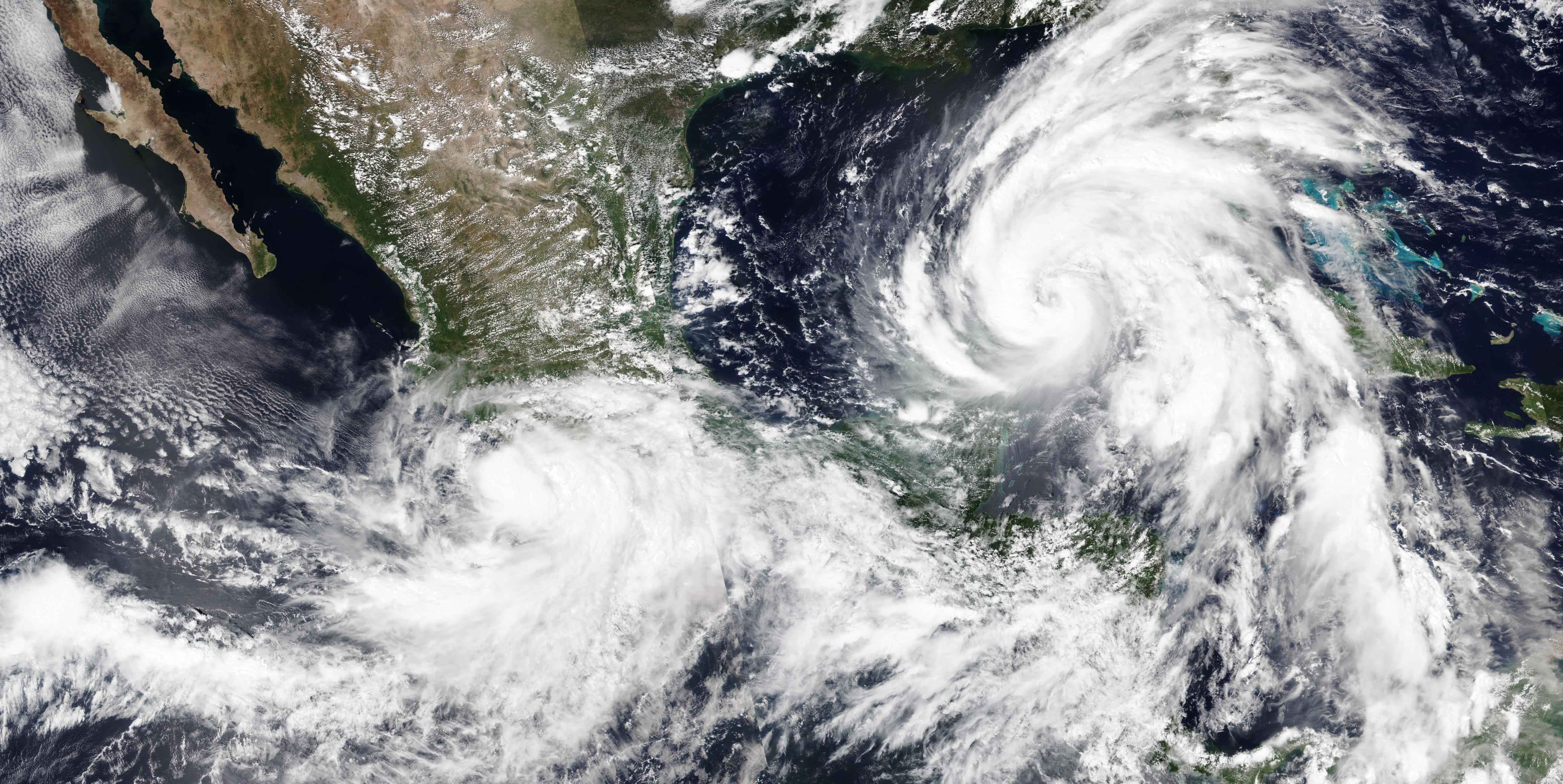
A shift to a cooler AMO phase could reshape hurricane patterns in the Atlantic. In 2024, the National Hurricane Center (NHC) released models suggesting that while overall hurricane frequency might decrease, individual storms could become more intense due to changes in ocean-atmosphere dynamics. The study projected a potential 20% decline in named storms but warned of a higher proportion of Category 3 or stronger hurricanes. This paradox arises because cooler surface waters can limit storm formation, but the altered jet streams and wind shear patterns may favor rapid intensification of storms that do form. The 2020 and 2021 hurricane seasons have already shown the unpredictability of storm behavior in a changing climate. Coastal cities from Miami to New York are revisiting their disaster preparedness plans in light of these findings, with insurance companies also adjusting their risk models. The NHC’s ongoing surveillance and forecasting efforts are now more crucial than ever, as unpredictable storm behavior poses new threats to vulnerable communities.
Climate Policy and Preparedness
The prospect of an AMO phase change is prompting governments to rethink climate policy and disaster readiness. The Intergovernmental Panel on Climate Change (IPCC) issued a 2024 guidance urging policymakers to incorporate natural climate cycles like the AMO into risk assessments and adaptation plans. The Climate Policy Initiative’s latest report underlines the need for flexible policies that can respond to cyclical climate volatility rather than relying solely on long-term warming trends. Several countries, including the United States and United Kingdom, have begun integrating AMO-based scenarios into their coastal management and agricultural planning strategies. Emergency management agencies are also updating flood maps and evacuation protocols to reflect the shifting risks associated with a cooler AMO. These moves are seen as essential for minimizing economic damage and loss of life during extreme weather events. The policy landscape is rapidly evolving, with greater emphasis placed on dynamic, science-based decision-making.
Economic Consequences: Agriculture and Fisheries

Agriculture and fisheries are two sectors especially vulnerable to changes in the AMO. The Food and Agriculture Organization (FAO) reported in April 2024 that shifts in North Atlantic water temperatures are already influencing fish migration, with Atlantic cod and herring moving further north than in previous decades. This migration threatens the livelihoods of fishing communities from New England to Scandinavia. Similarly, the Midwest United States has seen early signs of changing rainfall patterns, with corn and soybean yields fluctuating more than usual over the past two years. The U.S. Department of Agriculture is advising farmers to diversify crops and improve irrigation systems to cope with these uncertainties. In Europe, wine producers in France and Italy are also monitoring rainfall and temperature changes that affect grape quality and harvest timing. These economic disruptions highlight the interconnectedness of climate cycles and day-to-day business operations, making adaptation a top priority for both industries.
Regional Variations: Global Perspectives
The effects of the AMO are distributed unevenly across regions, complicating the global response. A 2024 study in *Geophysical Research Letters* showed that while the Caribbean and southeastern U.S. may see reduced hurricane activity, Western Europe could face a 15% increase in extreme rainfall events. In West Africa, the AMO’s cooling phase is linked to decreased rainfall in the Sahel, which could worsen food insecurity for millions. Meanwhile, Arctic regions might experience faster ice melt due to changes in ocean currents triggered by the AMO shift. In South America, Brazil’s northeast is bracing for prolonged droughts, as previous AMO cool phases have disrupted monsoon-like rainy seasons. Governments in each of these regions are developing localized adaptation plans, reflecting the complexity and diversity of AMO impacts. Regional disparities in climate vulnerability underscore the need for international cooperation and information sharing.
Public Awareness and Education
Public understanding of the AMO remains limited, even as its influence grows. In 2024, NOAA launched a nationwide campaign to raise awareness about the AMO, partnering with schools, local governments, and media outlets. Educational materials now explain the AMO in plain language, using animations and real-world examples to show how it affects everything from summer storms to winter heating bills. Community workshops in hurricane-prone areas are emphasizing the importance of preparedness, regardless of whether overall storm numbers rise or fall. Social media platforms have also become key tools for spreading information, with meteorologists regularly sharing updates and forecasts related to the AMO. Public engagement efforts are helping people understand that climate change is not just about gradual warming, but also about natural cycles that can trigger sudden shifts in weather patterns. This growing awareness is expected to drive more demand for climate-smart infrastructure and insurance options.
Scientific Research and Future Projections

Cutting-edge research into the AMO is advancing rapidly. The National Center for Atmospheric Research (NCAR) unveiled new climate modeling software in January 2024, capable of simulating the AMO’s impacts decades into the future. Scientists from institutions such as MIT, the University of Miami, and the UK Met Office are collaborating on international projects to pool data and improve forecasts. A peer-reviewed study published in March 2024 found that combining oceanographic, atmospheric, and satellite data produced more accurate AMO phase predictions than previous models. Researchers are also investigating the possible interaction between the AMO and other cycles, such as El Niño and the Pacific Decadal Oscillation, to understand compound climate risks. The scientific community agrees that sustained investment in monitoring networks, including ocean buoys and satellites, is essential for early detection of phase changes. These efforts will inform policymakers and help communities prepare for whatever the AMO’s next phase brings.
Preparing for Change: The Path Ahead
With mounting evidence that the AMO could shift to a cool phase in 2025, public agencies, businesses, and individuals are being urged to step up preparations. Emergency management teams in the U.S. and Europe are reviewing their response protocols for both floods and droughts. Coastal cities are investing in green infrastructure and updated flood control systems, while agricultural extensions are providing new climate-resilient crop varieties to farmers. The insurance industry is adjusting risk models and policies to reflect the shifting probabilities of extreme weather events. International organizations are convening forums to share best practices and coordinate responses across borders. As stakeholders mobilize, the message from experts is clear: proactive adaptation and cross-sector collaboration are the best defenses against the unpredictable impacts of an overlooked but powerful climate cycle.