


- What Earth’s Magnetic Field Has to Do With Climate History - October 7, 2025
- The Science Behind Heat Domes and Their Growing Impact - October 7, 2025
- What Ancient Lake Beds Teach Us About Past Rainfall Patterns - October 6, 2025
The Polar Vortex Connection
When you step outside on a pleasant April morning only to find yourself shivering by afternoon, there’s often a powerful atmospheric player behind the scenes. The polar vortex is a large area of low pressure and cold air surrounding both of the Earth’s poles. It ALWAYS exists near the poles, but weakens in summer and strengthens in winter. Depending on where those lobes of Arctic chill go, the stage could be set for at least a one-to-two week period of cold, stormy weather east of the Rocky Mountains by around mid-March.
The really fascinating part is how this massive atmospheric system can suddenly shift and send frigid air marching southward. A disrupted polar vortex increases the odds that the tropospheric jet stream will stay shifted farther south, which increases the risk for cold air outbreaks over the eastern United States and Europe. Most importantly, this “loading of the dice” for cold air can persist for up to 6 weeks after the vortex is disrupted.
Sudden Stratospheric Warming Events
One of the most dramatic causes of spring temperature drops happens miles above our heads in a phenomenon that sounds like science fiction. When the polar vortex is disrupted via a major, sudden stratospheric warming, temperatures in the polar stratosphere increase, sometimes becoming warmer than the air in the tropical stratosphere. Now the air is moving from the polar region to the tropics. The air is deflected to the right by Earth’s rotation, causing the winds to blow from east-to-west (easterlies).
These events often occur during late winter and early spring, creating perfect conditions for unexpected cold snaps. Though the impacts of March sudden warmings are very similar to those in mid-winter, spring is coming, so any Arctic air brought down in the US won’t “feel” as cold compared to if it happened in January because we are in a warmer part of the year. The timing of these disruptions makes them particularly dangerous for agriculture and gardening enthusiasts who’ve already started their spring planting.
La Niña’s Role in Spring Temperature Swings

Ocean temperatures thousands of miles away can dramatically influence your local spring weather patterns. Historically, a La Niña winter has a 60-75% chance of producing a Stratospheric Warming Event (SSW). As you can see, a La Niña phase has a higher chance of producing a Polar Vortex collapse event. Overall, this means that a La Niña event is unfavorable for a strong Polar Vortex, at least on average.
This creates a domino effect where Pacific Ocean conditions can trigger atmospheric disruptions that eventually send cold air streaming into regions experiencing their typical spring warmup. La Niña has transitioned to neutral, which can lead to more varied weather – such as shifts in rainfall, temperature swings, or changes in storm patterns across different regions. The Pacific is transitioning from La Niña to neutral conditions, shifting the jet stream and influencing storm tracks. When these transitions happen during spring months, they’re particularly notorious for causing weather whiplash.
False Spring Phenomenon
Perhaps no weather event is more heartbreaking for gardeners and farmers than the dreaded false spring. In a weather whiplash known as “false spring,” a hard freeze that occurs after the spring bloom can damage or even kill an entire crop. While plants are highly resilient to freezing temperatures while protected during the winter months, they become more vulnerable to temperature extremes after the spring bloom.
This happens because plants begin their growth cycles based on warming temperatures and longer daylight hours, only to be caught off-guard by returning cold. The mild thermal conditions in these regions supported the strengthening of late-sown winter cereals, but weakened the low-temperature tolerance, thus increasing the risk of frost damage. It’s nature’s cruelest trick – giving life the green light to flourish, then pulling the rug out from underneath.
Climate Change’s Complex Impact

You might think global warming would eliminate spring cold snaps, but the reality is far more complicated. Climate Central analyzed 55 years of temperature data and found that meteorological spring (March – May) has warmed across the U.S. from 1970 to 2024. The spring season has warmed in 234 (97%) of the 241 U.S. cities analyzed – by 2.4°F on average.
However, this warming trend doesn’t mean we’re immune to sudden temperature drops. It makes sense that the polar vortex tends not to be as strong due to global warming because the planet isn’t warming uniformly. It’s warming more at the pole, overall decreasing the strength of the polar vortex and the jet stream and making it more susceptible to being dislodged and sent our way. This creates a paradoxical situation where overall warming can actually increase the frequency of dramatic cold outbreaks during spring months.
The Jet Stream’s Wavering Path
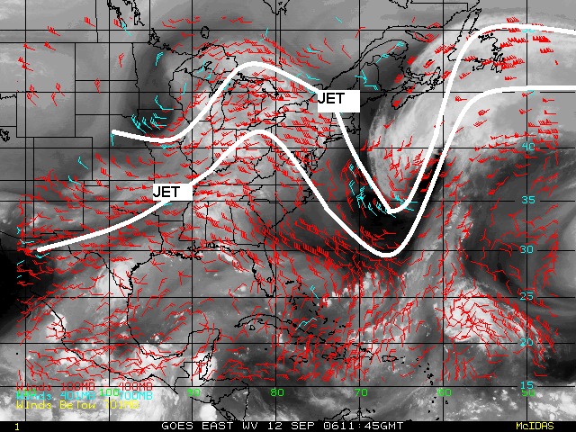
The jet stream acts like a massive atmospheric highway that usually keeps Arctic air locked up north, but when it starts to meander, all bets are off. Disruptions to the polar vortex can communicate down to the troposphere and disrupt the jet stream. These disruptions to the jet stream can bring colder than normal Arctic air down into the eastern United States.
Think of it like a river that normally flows straight but suddenly develops massive loops and curves. When the jet stream becomes wavy or “meridional,” it can create deep troughs that act like express lanes for Arctic air masses. The shift in placement of cold air masses can also establish “storm tracks,” which favor corridors of more active weather. These atmospheric highways can deliver bone-chilling air to regions experiencing their spring warmup, creating dramatic temperature drops that catch everyone by surprise.
Late Season Frost Damage Risks
The agricultural implications of sudden spring temperature drops extend far beyond disappointed gardeners. The damage induced by LSFs to vulnerable plant organs markedly affects growth, health, competitive ability and distribution limits of plants, and, in North America and Europe, causes more economic losses to agriculture than any other climate-related hazards.
The economic impact ripples through entire food systems when spring cold snaps strike at the wrong time. In Denmark, the sudden temperature drop followed a period of abundant rainfall, which led to frozen waterlogged fields, locally associated with mechanical damage to winter crops. The sharp temperature drop in the Baltic Sea region in late December and early January likely caused frost damage to winter crops, especially in Estonia, Latvia, and Lithuania, where the snow layer was relatively thin. These events demonstrate how vulnerable our food systems are to rapid temperature fluctuations.
Arctic Oscillation Influences
The Arctic Oscillation is like a atmospheric seesaw that helps determine whether cold Arctic air stays put or ventures southward during spring months. When this oscillation shifts to its negative phase, it weakens the barriers that typically keep frigid air confined to polar regions. As the seasons change, the vortex descends toward the equator, and we experience those blasts of cold air, as we did this past month. The polar vortex disruption resulted in a wavy polar jet stream; the warm air was concentrated at the pole, and the cold air sunk toward the equator.
This atmospheric pattern creates a perfect storm scenario where multiple systems align to send temperatures plummeting just when plants and people expect spring-like conditions. The oscillation can persist for weeks, creating extended periods of unseasonably cold weather that can devastate crops and frustrate anyone eager for warm weather.
Spring Frost Frequency Changes

Traditional wisdom about when to expect the last frost of the season is becoming increasingly unreliable as climate patterns shift. This map of the United States shows the most common date range you can expect to see temperatures dip to 32°F or below for the last time. The map also reveals some interesting regional differences across the country. In the Northeast and Southeast, the last spring freeze date generally progresses through time moving northward on the map.
However, historical averages are becoming less predictable guides for farmers and gardeners. It is readily apparent that the phrase “average last freeze date” is quite relative, as most sites feature a 5-9 week difference between the earliest and latest dates! For some of these locations, the incredibly-early last freeze of spring 2012 (between March 9-11) was among the earliest on record. On the opposite spectrum, for several places the latest freeze of the last 30 years occurred in mid-May 2014. This increasing variability makes planning for spring weather more challenging than ever.
Temperature Gradient Disruptions
The contrast between warming land surfaces and still-cold northern regions creates unstable atmospheric conditions that can trigger sudden temperature drops. As spring progresses, the temperature difference between polar and temperate regions becomes more pronounced, creating energy that can fuel dramatic weather changes. An increase in growing season length may sound like a great thing for food production, but as we’ll see, that can make plants more vulnerable to late frosts and can also allow for more generations of pests per growing season, thus increasing pest pressure.
This temperature instability acts like a loaded spring, ready to snap when atmospheric conditions align just right. The greater the contrast between warm and cold air masses, the more dramatic the potential temperature swings can be when systems collide during the transitional spring season.
Stratospheric-Tropospheric Communication
The interaction between different layers of our atmosphere creates a complex communication system that can send cold signals from high above down to the surface level where we feel them. It usually takes a week or two for the signal to translate from the upper atmosphere – known as the stratosphere, where the disruption comes with a pronounced warming – to the lower atmosphere, or troposphere. At this time of year, winter is fighting a losing battle against the seasonal cycle (and that’s in addition to the warming climate).
This delayed response system means that sudden temperature drops often seem to come out of nowhere, but they’re actually the result of atmospheric disturbances that began days or weeks earlier high above our heads. Understanding this connection helps meteorologists provide better advance warning, but the complexity of these interactions still makes spring weather forecasting particularly challenging.
The unpredictable nature of spring weather keeps us all guessing, whether we’re farmers planning our crops, gardeners eager to plant, or simply trying to decide what coat to wear. While science helps us understand the mechanisms behind these sudden temperature drops, the complex interplay of atmospheric systems ensures that spring will always have a few surprises up its sleeve. What would you have guessed about your local weather patterns now that you know these hidden forces at work?