

- Alaska’s 1,578-Foot Tsunami Was the Second-Tallest Ever Recorded - May 8, 2026
- The 7 Reasons Sunsets Look Different Than They Did 50 Years Ago - May 8, 2026
- 8 Lakes That Are Drying Up Across America - May 8, 2026
Water levels across the American West have been telling the same story for decades, and the numbers keep getting harder to ignore. From terminal desert lakes that have no natural outlet to massive reservoirs built to sustain millions of people, bodies of water that once seemed permanent are shrinking at rates that alarm scientists, water managers, and the communities depending on them. Climate change is causing extremely long periods of drought, particularly in the western United States, a region that has suffered extreme drought for over two decades.
The problem is not limited to any single cause. Rising water temperatures caused by climate change enhance evaporation, which dries out soil, and water sources are being consumed much faster than they can replenish themselves. What follows is a look at eight American lakes currently in various stages of decline, from cautiously stabilizing to dangerously close to the edge.
1. Great Salt Lake, Utah
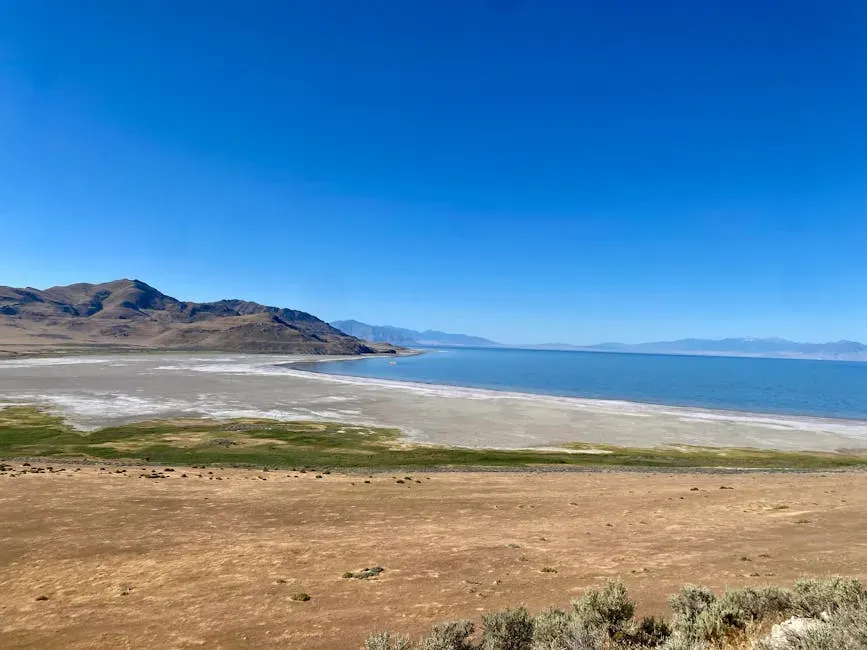
The Great Salt Lake is the Western Hemisphere’s largest saltwater lake and a terminal lake, meaning it has no outflow and loses water mainly through evaporation. Human development and use of water in the watershed have caused a decline in its water levels of eleven feet since the late 19th century, with declines accentuated by drought in more recent decades. The lake reached its historic high of 4,211.65 feet in 1986, covering roughly 3,300 square miles, then plunged to a historic low of 4,188.5 feet in November 2022.
As of the close of the 2025 water year, the lake recorded its third-lowest water levels on record, with experts and government officials stressing the urgent need for sustained, data-driven action. Thirty-year projections indicate that a sustained additional inflow of 800,000 acre-feet per year is necessary to return the lake to healthy levels by 2055. The lake contributes approximately $1.9 billion to Utah’s economy and creates jobs for nearly 8,000 Utahns each year, while lake-effect snow alone supports another $1.94 billion in the ski industry.
2. Lake Mead, Nevada and Arizona
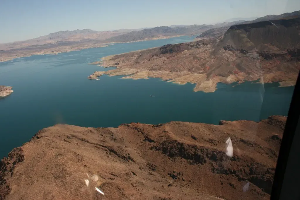
Lake Mead, located in the Colorado River Basin, is the largest reservoir in the United States in terms of capacity, capable of storing more than 26 million acre-feet of water. Since 2020, the reservoir has regularly broken record water lows, prompting massive water cuts across the region. The reservoir was created in the 1930s through the construction of the Hoover Dam and became the backbone of water supply across the Southwest.
As of early 2026, Lake Mead is projected to remain in a Level 1 Shortage Condition, with an expected elevation roughly twenty feet below the Lower Basin shortage determination trigger. The reservoir supplies vital water to millions in Nevada, Arizona, California, and parts of Mexico, and declining water levels could jeopardize city water systems, farm irrigation, and hydroelectric power output. Las Vegas alone would lose roughly nine-tenths of its water supply if water at Hoover Dam runs out entirely.
3. Lake Powell, Utah and Arizona
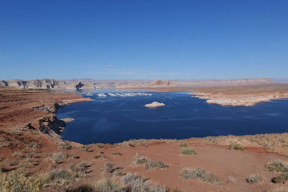
Lake Powell, the second-largest reservoir in the United States, was created in the 1960s with the construction of the Glen Canyon Dam. Lake Powell’s projected elevation for early 2026 stands at approximately 3,538 feet, about 162 feet below full pool and only 48 feet above the minimum power pool. Some forecasts have indicated that Lake Powell could potentially see water levels drop below its minimum power pool elevation of 3,490 feet as early as late 2026 if drought conditions worsen.
A 2025 analysis of the Colorado River described both the water supply and institutional systems as failing, noting that many of the environmental systems had already failed years earlier. Lake Powell and Lake Mead together sit at a combined storage of just about one-third of their total capacity. Federal officials have stressed that new, sustainable operating guidelines must be developed to ensure water security for more than 40 million people who rely on the Colorado River system.
4. Salton Sea, California
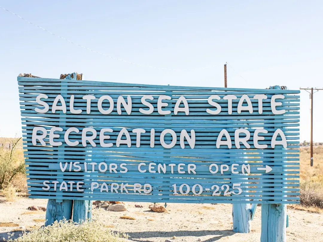
The Salton Sea is a huge, shallow lake located in California’s Sonoran Desert. Its increasing saltiness has killed off most of its once-abundant fish species, and its shrinking water level has caused a reduction in water available for agricultural use. A study published in 2024 confirmed the lake is experiencing accelerated shoreline retreat, following a policy change that redirected more Colorado River water to San Diego.
The shoreline along the Salton Sea’s North Shore is projected to recede by 150 meters by 2030 and an additional 172 meters by 2041 if the current rate continues. As the lakebed dries, it generates fine particulate matter pollution, and wind-driven dust storms from the exposed lakebed have already impacted air quality in surrounding communities. Children who live around the Salton Sea have reduced lung function and suffer from what scientists have described as a novel form of asthma.
5. Walker Lake, Nevada
Walker Lake has been drying up for decades due largely to agricultural and ranching diversions, with one nonprofit organization calling its decline “an ecological tragedy more than a century in the making.” Beaches that once meant sunbathing, boat launches, and swimming now surround the diminished lake like a dirty bathtub ring, a stark visual reminder of how far water levels have dropped. The lake is what geologists call a terminal lake, meaning it sits at the end of the Walker River with no outlet, making any water removed upstream a direct loss to the lake.
With drastically reduced water levels, Walker Lake has been on the brink of ecological collapse, though record snowpack years have periodically sent large volumes of water flowing back toward the basin. Health-related impacts from drying lakes like Walker are well-documented, with communities near similar water bodies reporting elevated illness rates tied to dust and declining water quality. The slow disappearance of Walker Lake has also carried significant cultural weight for the Walker River Paiute Tribe, whose connection to the water spans generations.
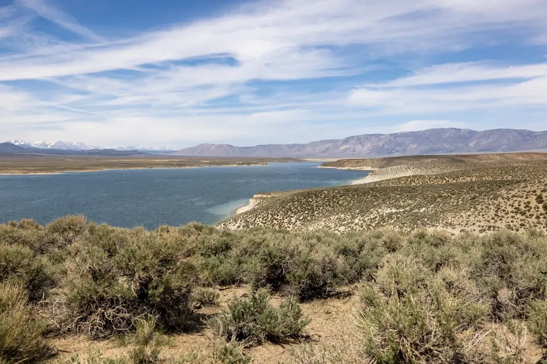
6. Mono Lake, California
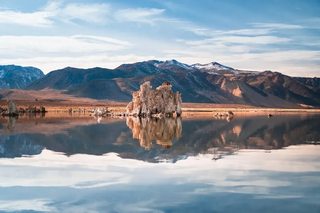
If you live in Los Angeles, a significant portion of your drinking water has historically come at the expense of Mono Lake and Owens Lake, both of which have suffered sustained losses as a result. Mono Lake, located near the eastern Sierra Nevada in California, is another terminal saline lake with a fragile and irreplaceable ecosystem. Los Angeles is legally entitled to take up to 16,000 acre-feet from the lake’s tributaries in a water year, enough to serve as many as 200,000 people, or roughly five percent of the city’s population.
In the Great Basin, which spans six states in the American West and contains more than twenty major salt lakes including Mono, waterbird populations have declined by roughly seventy percent since 1973. Mono Lake itself hosts enormous concentrations of migratory birds and brine shrimp, and the lake’s health is tied directly to how much water Los Angeles chooses to divert upstream. In its most recent annual operating plan, the Los Angeles Department of Water and Power indicated it could take as little as 4,500 acre-feet from the basin, far below its maximum legal entitlement, as part of an effort to allow the lake to recover.
7. Owens Lake, California
Owens Lake in eastern California is described as nearly gone, a casualty of sustained water diversions that redirected its primary inflows to feed Los Angeles. The dry lakebed of Owens Lake is a source of fine particulate matter that causes exceedances of national air quality standards, and it produces more dust pollution than any other single site in the United States. What was once a navigable lake large enough to support steamboats is now mostly an exposed, windswept playa.
Communities near Owens Lake, alongside those near similarly depleted lakes like Mono and Walker, have reported elevated illness rates tied to airborne dust and deteriorating environmental quality. The exposed lakebeds left behind by receding water contain residue from pesticides, arsenic, mercury, and other industrial and agricultural toxins, essentially becoming poisonous deserts whose dust storms lift thousands of tons of contaminated sediment into the air. Dust mitigation costs at Owens Lake have grown significantly, illustrating the long-term financial burden that a dried lakebed can impose on surrounding communities for generations.
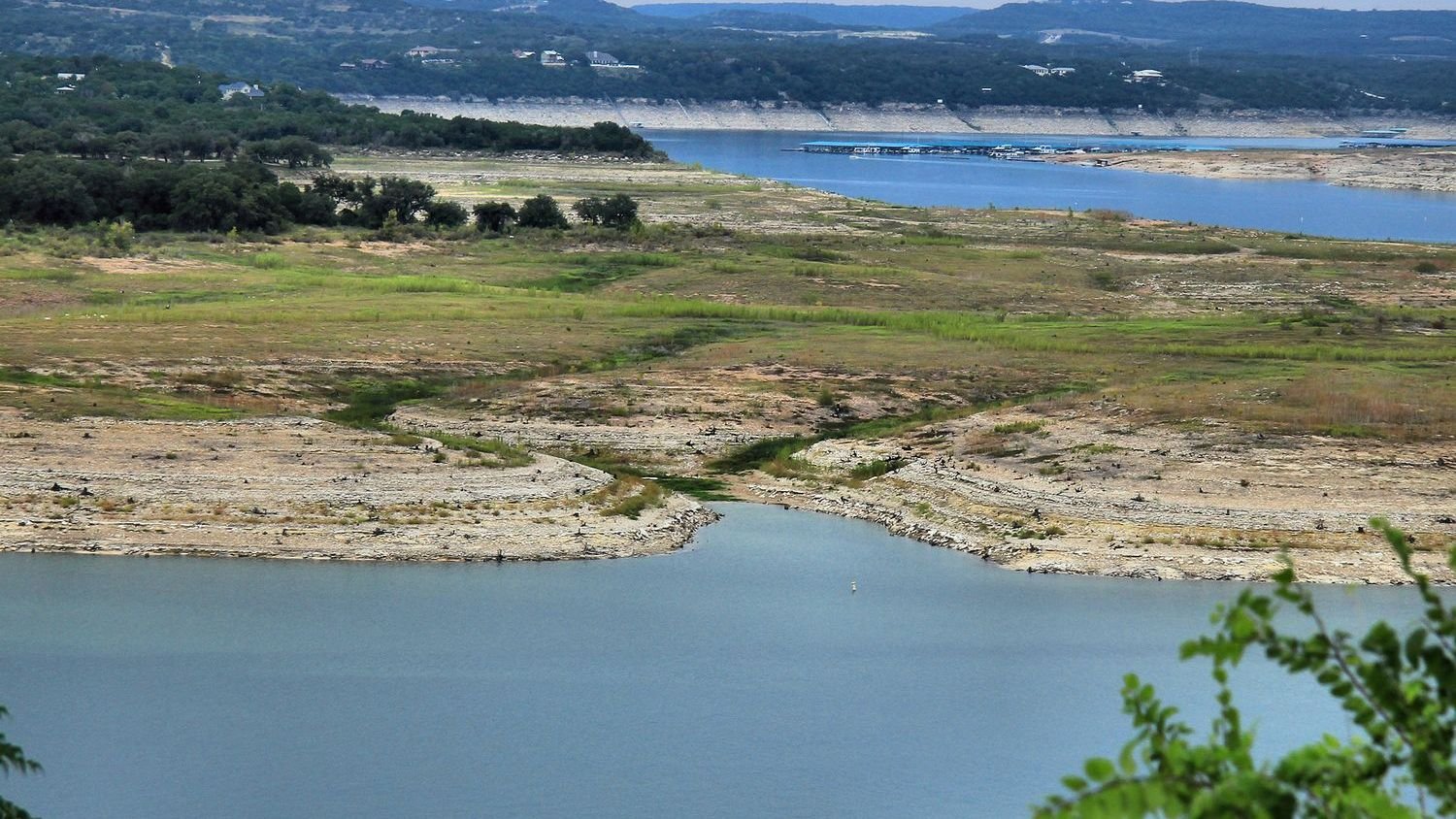
8. Lake Travis, Texas
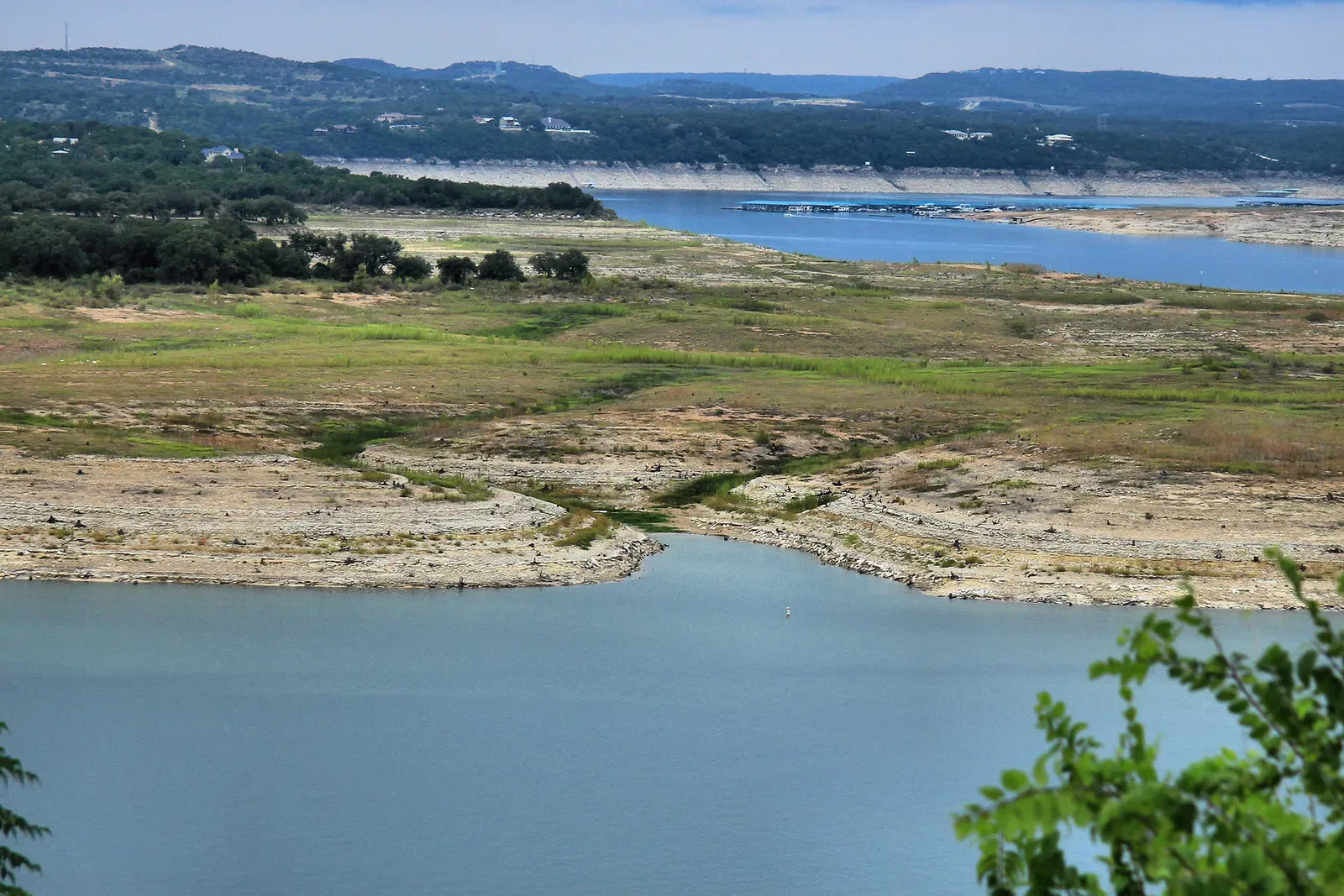
Lake Travis, the largest reservoir supplying Austin, Texas, was only about 38 percent full in January 2024, down from 80 percent full just two years earlier in January 2022. Years of drought had depleted the lake’s water levels to such low points that they exposed objects normally hidden underwater, including an old concrete plant and pecan groves. The lake’s chronic vulnerability to drought reflects a broader pattern across Texas, where water infrastructure is repeatedly tested by the collision of rapid population growth and prolonged dry spells.
Before devastating floods inundated Central Texas in the summer of 2025, Lake Travis had been sitting at just 43 percent full. Following that unusual influx from flooding, water levels began declining again as conditions normalized, though Central Texas is entering a wetter seasonal pattern that may offer some near-term relief. If drier conditions return before late summer, the region could find itself very close to triggering Stage 1 drought contingency plans, which would require mandatory water use reductions across cities, utilities, and industries.
Across all eight of these lakes, the underlying pressures are remarkably consistent: long-term drought, growing water demand, agricultural diversions, and warming temperatures that accelerate evaporation faster than natural cycles can replenish. Research published in the journal Science found that more than half the decline in natural lakes globally is driven by climate warming and human consumption, with warming accounting for the larger share. Some of these lakes have stabilized temporarily thanks to above-average snowpack years or conservation programs. Others are running out of time. The real question is not whether they matter, but how long meaningful action can be deferred before the losses become irreversible.