

- The 7 Most Unusual Storms in American History - May 9, 2026
- Alaska’s 1,578-Foot Tsunami Was the Second-Tallest Ever Recorded - May 8, 2026
- The 7 Reasons Sunsets Look Different Than They Did 50 Years Ago - May 8, 2026
Most people picture a storm as something that arrives with dark clouds, pours rain, and moves on. But American history is filled with weather events that broke every expected pattern, storms that behaved in ways that left scientists scrambling for explanations and ordinary people genuinely terrified. Some brought summer snow. Others generated tornadoes made of fire. A few erased entire communities before anyone understood what was happening.
What follows are seven storms that stand apart not just for their destruction but for their sheer strangeness, each one a reminder that American weather, in its most extreme form, is a force unlike anything else on the continent.
The Summer That Never Came: The “Year Without a Summer” Storm System of 1816
The year 1816 is known as the Year Without a Summer because of severe climate abnormalities that caused average global temperatures to decrease significantly. Evidence suggests that the anomaly was predominantly a volcanic winter event caused by the massive eruption of Mount Tambora in the Dutch East Indies in April 1815. The ash cloud spread across the Northern Hemisphere, dimming the sun and triggering a cascade of bizarre weather across the young United States.
May frost killed off most of the crops in New York, Massachusetts, New Hampshire, and Vermont. In June, heavy snow smothered the ground in Albany, New York and Dennysville, Maine, while frost persisted for five consecutive nights in Cape May, New Jersey. In July, lakes and rivers remained frozen as far south as northwestern Pennsylvania, while frost remained in Virginia into late August. These conditions forced many families to leave their homes in search of better farming opportunities, contributing to Westward expansion.
A Hurricane That Defied All Logic: Superstorm Sandy, 2012
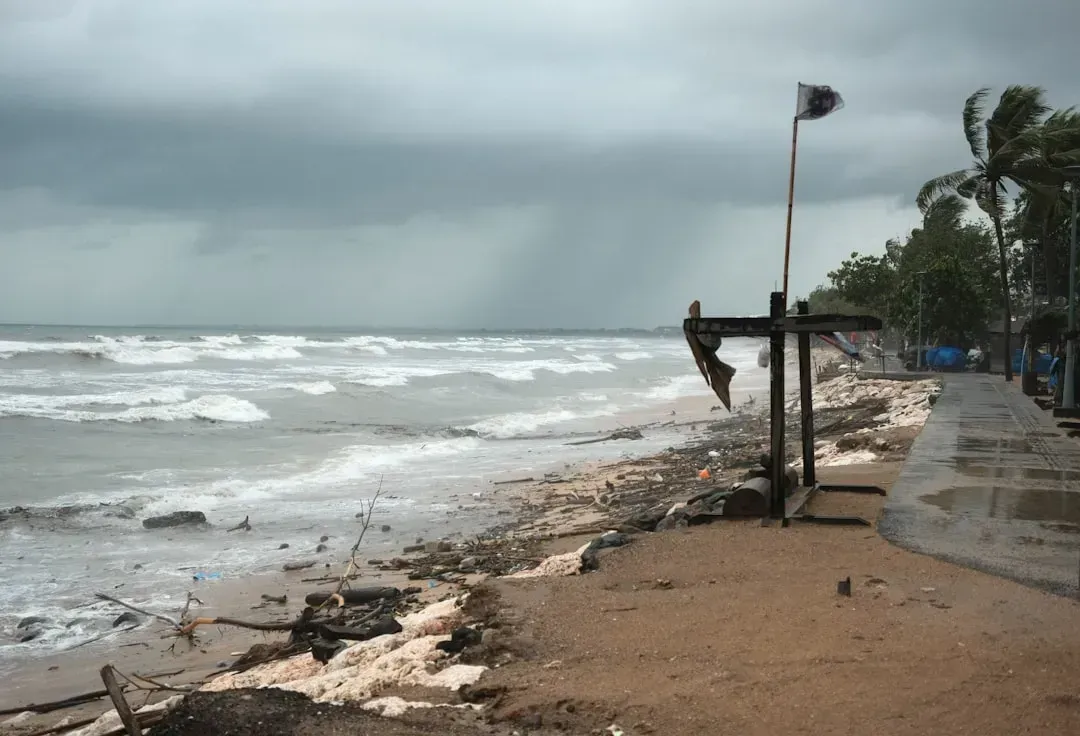
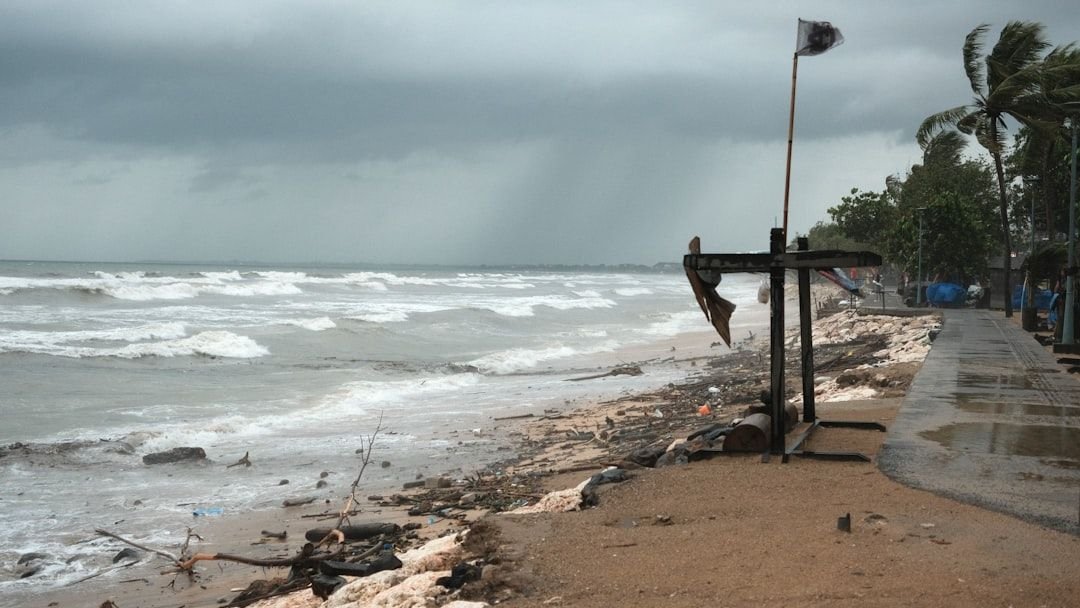
Dubbed a “Frankenstorm” for its bizarre convergence of a hurricane with a nor’easter, Sandy struck the Eastern Seaboard in late October 2012. Sandy was a unique event for several reasons: it was the most powerful in terms of integrated kinetic energy along the storm’s track and the third most destructive Atlantic hurricane in recorded history. Its sheer scale defied the standard rules of tropical meteorology entirely.
After taking a freakishly rare west-northwesterly track into New Jersey, Sandy’s tropical-storm-force winds at landfall spanned 943 miles of the U.S. Sandy made landfall near Atlantic City, NJ, with sustained winds of 80 mph and a central minimum pressure of 946 mb, the lowest pressure on record along the Northeast U.S. coast. Such was Sandy’s massive circulation that at one point it was snowing in the mountains of Virginia and West Virginia while at the same time temperatures were in the low 70s in Vermont. No single storm had produced such a contradictory weather map across the country in living memory.
The Tornado That Broke the Rulebook: El Reno, Oklahoma, 2013
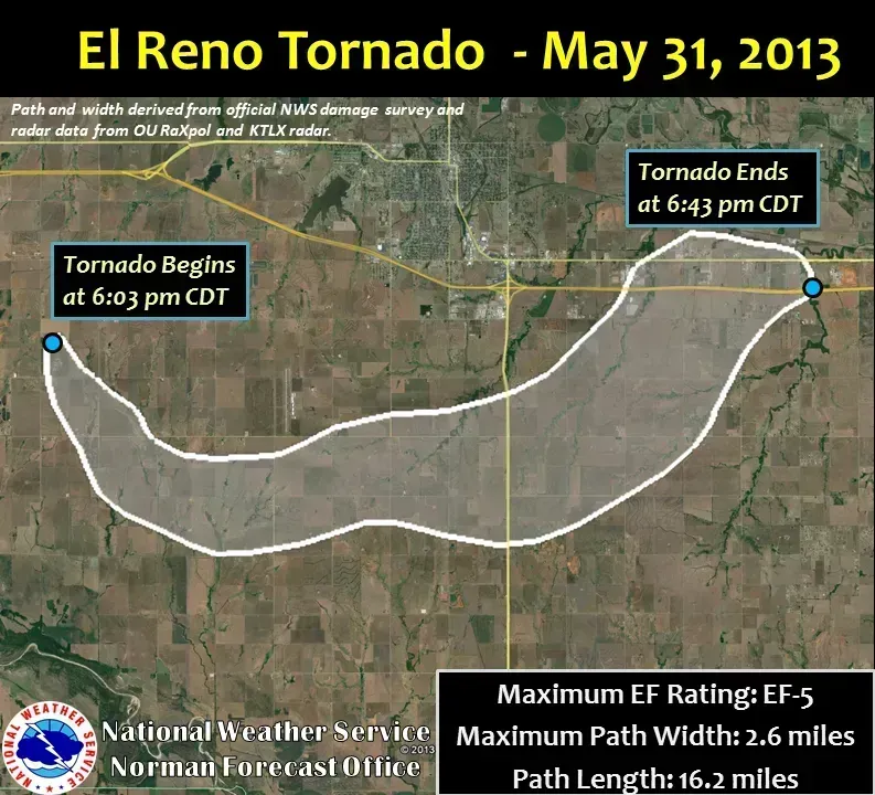
The 2013 El Reno tornado was an extremely large, powerful, and erratic tornado that occurred over rural areas of Central Oklahoma during the early evening of Friday, May 31, 2013. This rain-wrapped, multiple-vortex tornado was the widest tornado ever recorded, peaking at 2.6 miles across. Most tornadoes that earn their fearsome reputation stay visible and relatively predictable. El Reno was neither.
Measurements from mobile weather radars revealed extreme winds in excess of 313 mph within sub-vortices. These are among the highest observed wind speeds on Earth. This tornado claimed eight lives, including three experienced storm researchers. The storm’s erratic movement pattern and rapid intensification caught many people off guard, including seasoned professionals who had tracked storms for decades. The National Weather Service referred to the tornado as “the most dangerous tornado in storm observing history.”
Fire Meets Tornado: The Carr Fire Tornado, California, 2018
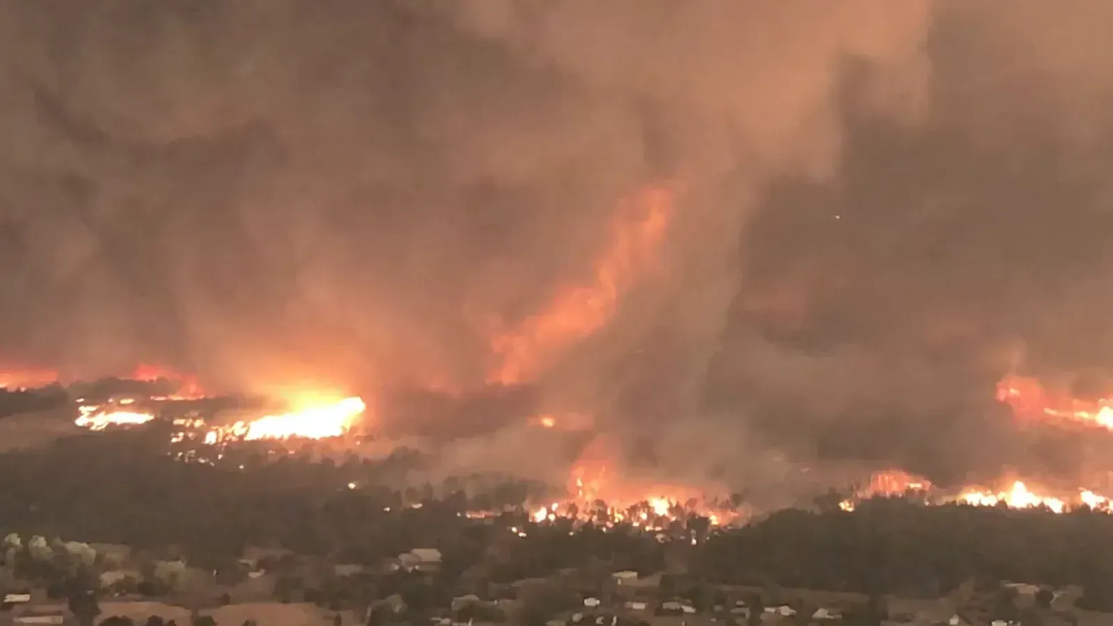
The fire tornado near Redding on July 26, during what was called the Carr Fire Event, was unprecedented in terms of its size and ferocity. Intense wildfires almost always produce fire devils and fire whirls, and very occasionally stronger vortexes that resemble the tornadoes produced by severe thunderstorms. California had seen weak weather-related whirls before, but nothing on this scale.
Video evidence and storm damage assessments following the fire tornado near Redding expanded what was previously considered the upper limits of fire-tornado intensity, with the wind associated with the tornado estimated at 143 mph, placing it in EF3 territory. Sadly, one fireman lost his life when he was caught in the tornado’s path. Prior to the Carr Fire event, there had never been a tornado-caused fatality in the state’s modern history except for one caused by another fire-related twister in 1926. The 2018 fire tornado ranks as one of the most anomalous weather-related events in modern U.S. history.
The Blizzard That Built Cities: The Great White Hurricane of 1888
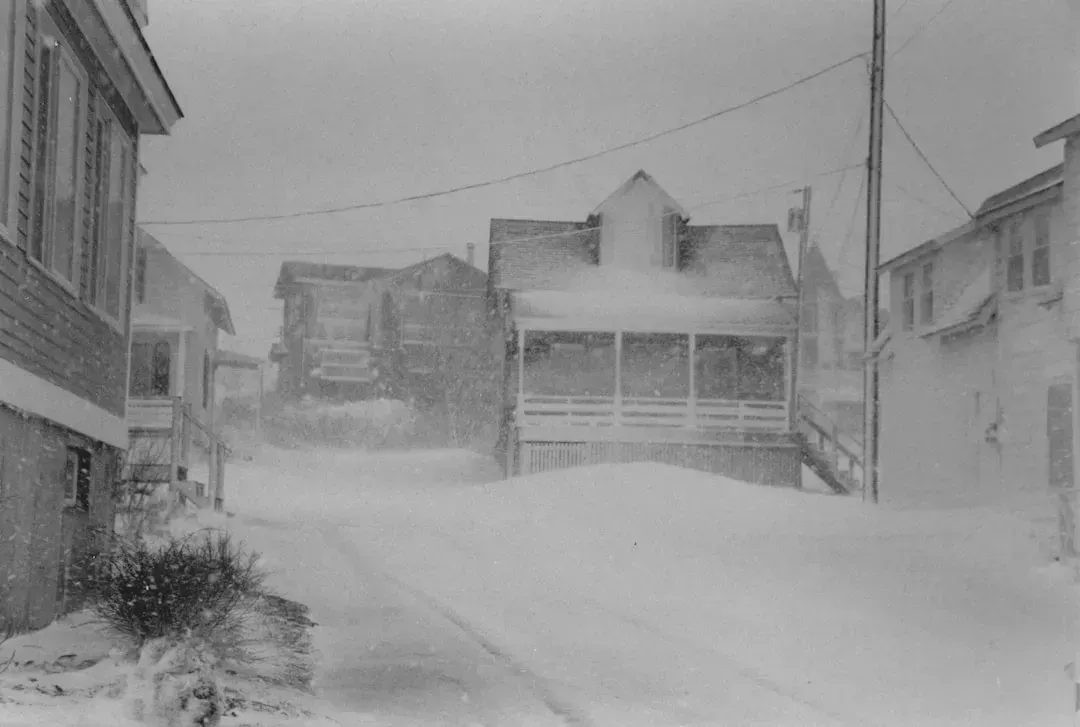
More than 120 winters came and went since the so-called “Great White Hurricane,” but this storm still lives in infamy. After a stretch of rainy but unseasonably mild weather, temperatures plunged and vicious winds kicked up, blanketing the East Coast in snow and creating drifts up to 50 feet high. The storm arrived so suddenly that thousands of people were caught entirely unprepared in the streets of major American cities.
The storm immobilized New York, Boston and other major cities, blocking roads and wiping out telephone, telegraph and rail service for several days. When the skies finally cleared, fires and flooding inflicted millions of dollars of damage. The disaster resulted in more than 400 deaths, including 200 in New York City alone. In the decade that followed, partly in response to the 1888 storm and the massive gridlock it wrought, New York and Boston broke ground on the country’s first underground subway systems. A single storm, in a strange way, helped reshape how America’s greatest cities were built.
The Storm of Impossible Rain: The Smethport Deluge of 1889
One of the most extraordinary rain events in U.S. and world history unfolded at the unlikely location of McKean County, Pennsylvania, located in the north-central portion of the state near the New York border. Nothing about the area made it a logical candidate for a record-breaking rainfall. That’s part of what made it so startling.
Six inches of rain fell between midnight and about 9 am on July 18, ordinarily a flooding rainfall in its own right. Then between 9 am and noon another 28.50 inches fell. All told, 34.50 inches of rain fell in an 18-hour period, of which 34.30 inches fell in just 12 hours and 30.80 inches in just 4.75 hours. For context, many parts of the country receive that much rain in an entire year. The physics of what produced such a concentrated burst remain a subject of study even today.
The Tri-State Tornado: A Storm That Rewrote What Was Possible, 1925
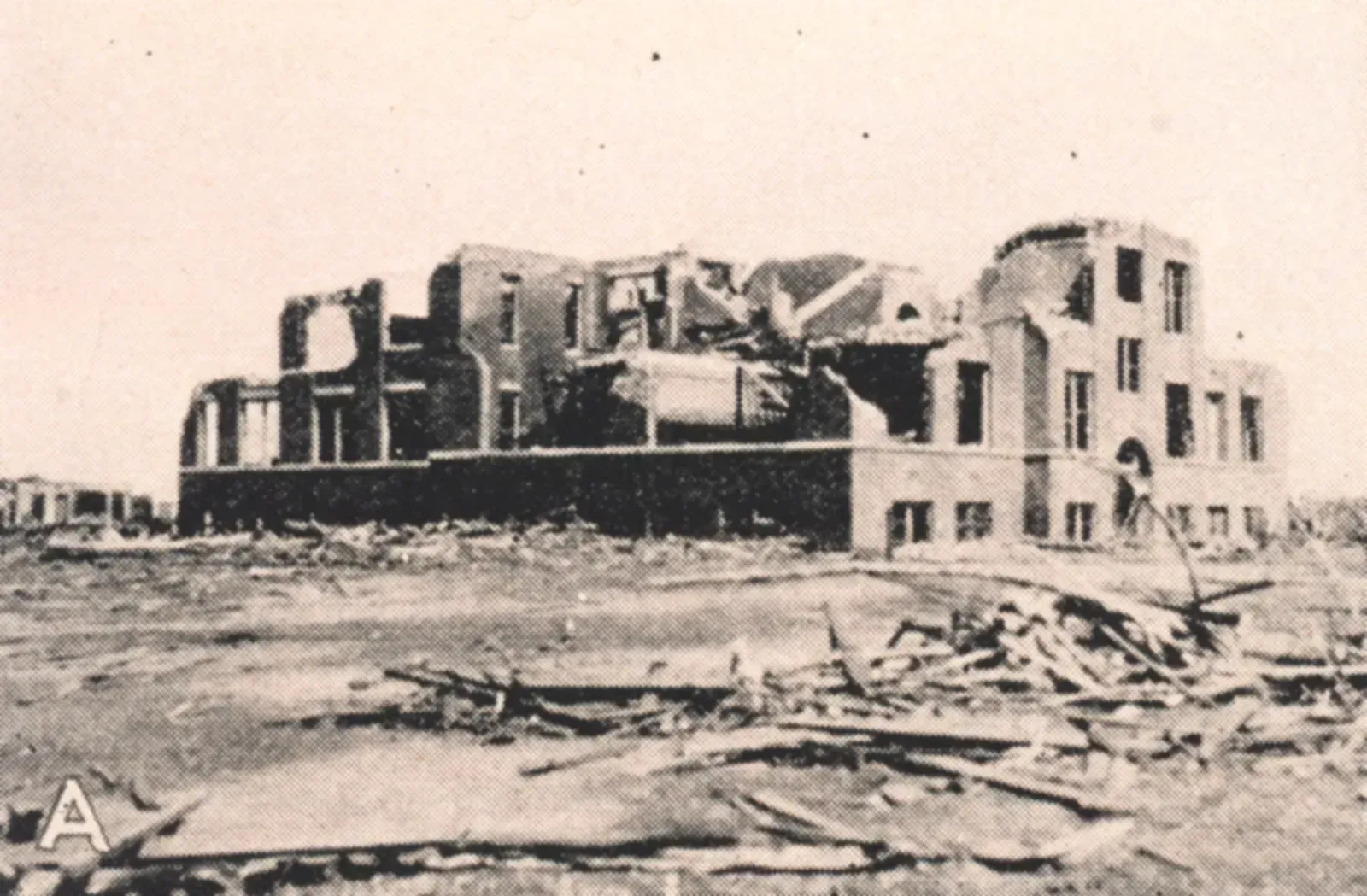
On March 18, 1925, a single tornado carved a path of destruction over 219 miles through Missouri, Illinois, and Indiana, killing 695 people, the deadliest tornado . Fooled by the low “rolling cloud” appearance, many didn’t sense the danger in time. Unlike modern tornadoes that are tracked in real time by radar and satellite, residents in 1925 had almost no warning at all.
Over three and a half hours, a tornado averaging a quarter-mile wide but at times growing to a mile left a 219-mile path of destruction in Missouri, Illinois and Indiana. It’s the farthest-traveling and deadliest tornado in U.S. history, killing at least 689 people and injuring more than 2,000. Four towns were demolished. In total, 13 counties and 19 communities felt the effects. The sheer distance it traveled at sustained intensity remains unmatched by any other tornado in recorded American history, a fact that still astonishes atmospheric scientists nearly a century later.