

Something significant is brewing in the equatorial Pacific, and meteorologists are paying very close attention. Exceptionally warm waters and a developing El Niño are expected to boost tropical activity during the 2026 Eastern and Central Pacific hurricane season, raising the risk of direct impacts in Hawaii, Southern California, and parts of Mexico. For communities that don’t typically put hurricane preparedness at the top of their list, that’s a wake-up call worth taking seriously.
The timing matters, too. The Eastern Pacific hurricane season begins on May 15 and runs through November 30, and for the incoming season AccuWeather is predicting 17 to 22 named storms, nine to 13 of which could strengthen into hurricanes, with four to eight possibly becoming major hurricanes. That range sits well above historical baselines, and the driver behind those elevated numbers is a climate pattern with a long track record of reshaping Pacific storm activity.
What Is El Niño, and Why Does It Matter for Hurricanes?
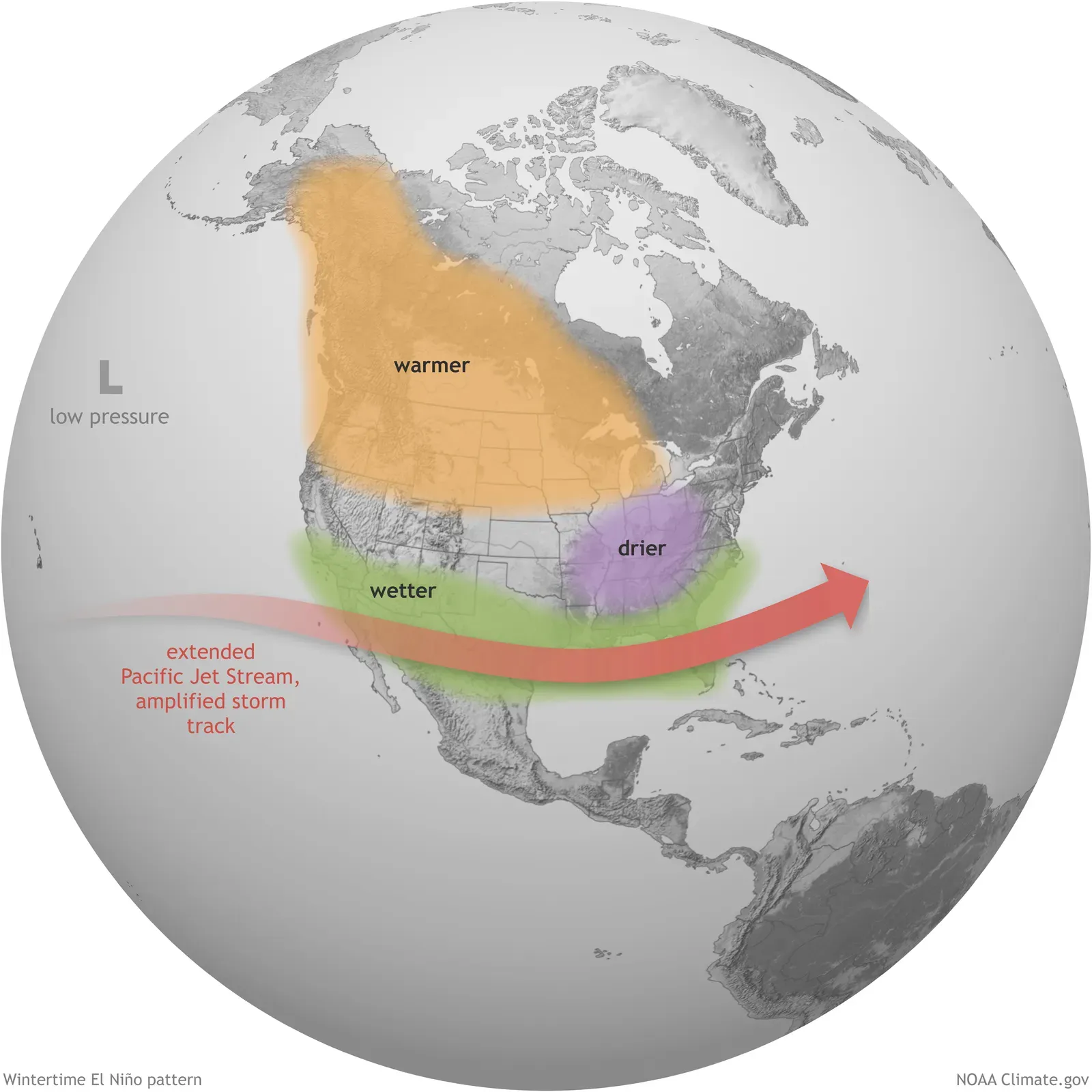
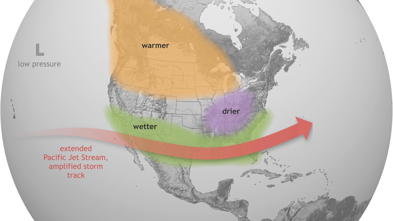
El Niño is a natural climate pattern marked by warmer-than-average water temperatures in the equatorial Pacific that also leads to changes in upper atmosphere patterns, and together, these factors influence weather globally. The mechanism behind its effect on tropical storms is relatively well understood. El Niño is known to favor increased hurricane activity in the eastern Pacific by limiting vertical wind shear that can otherwise tear storms apart.
El Niño is a periodic warming of water in the central and eastern equatorial Pacific Ocean that can affect global weather patterns for months, and there have been 27 El Niños since 1950, with one happening on average every three to four years. The last one happened from summer 2023 into early spring 2024. The key difference this time around is that conditions suggest the coming event could be considerably stronger than the typical cycle.
A Possible “Super El Niño” on the Horizon

A super El Niño is increasingly likely later this year, and it could become record strong with potential global impacts on rainfall and temperatures from summer through winter, as well as the 2026 hurricane season. The definition matters here. A strong El Niño, colloquially referred to as a “super El Niño,” occurs when average sea surface temperatures in the central and eastern equatorial Pacific rise at least 2°C above normal.
The majority of model forecasts now suggest there is at least a 50-50 chance this El Niño could become a “super El Niño,” one in which ocean surface temperatures are at least 2 degrees Celsius warmer than average. Reinforcing that concern, a surge of westerly winds near the equator in the western Pacific, called a westerly wind burst, is boosting confidence in the forecast. “These periods of strong winds blowing west to east are pushing warm waters onto the equator and driving them eastward, contributing to rapid warming in the eastern Pacific,” wrote Paul Roundy, a University of Albany professor and El Niño expert.
The 2026 Season Forecast by the Numbers
The forecast shows the Eastern and Central Pacific basins are expected to produce an above-average number of named storms, hurricanes, and major hurricanes in 2026. The Eastern Pacific hurricane season forecast calls for 17 to 22 named storms, nine to 13 hurricanes, four to eight major hurricanes, and six to nine direct impacts to Mexico and Central America. Those are sobering figures compared to what’s normal in a neutral year.
On average, the Eastern Pacific basin sees 15 named storms, 8 hurricanes, and 4 major hurricanes. Those averages were significantly higher during El Niño years, which produced 17 named storms, 9 hurricanes, and 5 major hurricanes. The FOX Forecast Center noted that while the exact timing of when El Niño develops is important, even moderate El Niño years have above-average tropical activity. Factor in the potential for a super El Niño later in the season, and the upper end of that forecast range starts to look very plausible. The Central Pacific hurricane season forecast calls for four to seven named storms, two to four hurricanes, one to three major hurricanes, and one to two direct impacts to Hawaii.
Southern California: An Underappreciated Risk
A new report from AccuWeather underscores growing concern among meteorologists that changing ocean conditions, largely influenced by the increasing chances of an El Niño year, could increase the likelihood of moisture-rich tropical storms or weakened hurricanes moving into the Southwestern U.S., bringing heavy rain, flooding, and dangerous surf to coastal and inland areas. This may strike some Californians as far-fetched, but recent history argues otherwise. AccuWeather hurricane expert Alex DaSilva explained: “Southern California is not a place where people usually think about tropical impacts, but the warm water and overall pattern deserve close attention. Hurricane Hilary in 2023 and Hurricane Kay in 2022 highlighted the risk of tropical rainfall and flooding impacts reaching Southern California.”
Ocean surface temperatures are cooler close to the California coast, which means most storms fall apart before they reach the Golden State. However, those temperatures are expected to be warmer than normal this year because of the developing El Niño, and although they won’t be warm enough to support tropical development, the warm waters could allow storms to move farther north than normal. AccuWeather’s DaSilva put it plainly: “The Pacific is unusually warm, and that raises the stakes this season. That extra energy stored in the ocean can help storms strengthen faster, last longer and in some cases move farther north toward places like Baja California and far Southern California.”
Hilary’s 2023 Warning Shot
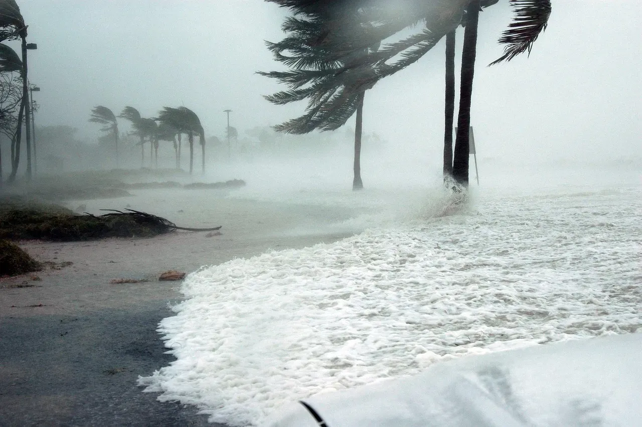
Tropical Storm Hilary in August 2023 gave Southern California a rare and jolting preview of what a tropical system can do to a region that hasn’t been designed to handle one. Hilary was the first tropical storm to hit Southern California in 84 years and dumped more than half the average annual rain on some desert and mountain areas. The remnants, which had been a Category 4 hurricane when churning in the Pacific before crashing ashore in Mexico, brought record-breaking rainfall to Southern California, flooding roads and causing mudslides and rockslides.
The National Weather Service Los Angeles said the storm had broken “virtually all rainfall daily records.” A record rainfall of 2.48 inches was set in downtown Los Angeles, breaking the previous record of 0.03 inches set in 1906. Rainfall totals from Hilary reached 13.5 inches in San Bernardino County. The storm forced widespread evacuations, shut down schools across the region, and left infrastructure that was never meant for tropical deluges overwhelmed in ways that took months to repair. Hilary was a vivid illustration of how dramatically the risk calculus can shift when a Pacific storm tracks farther north than usual.
Hawaii: The Islands in the Crosshairs
NOAA research shows that El Niño years bring above-average tropical cyclone activity in the Central Pacific basin. Warmer sea surface temperatures provide more fuel for storm development, and the shifted jet stream pattern can steer storms closer to the islands. Hawaii State Climatologist Pao-Shin Chu has noted the elevated danger in specific terms: El Niño years have increased hurricane activity within 250 miles of Honolulu, based on his analysis, which means everyone needs to prepare for the possibility.
Only two recorded hurricanes have actually made landfall in Hawaii: Hurricane Dot in 1959 and Hurricane Iniki in 1992, which both tore through Kauai. Hurricane Iniki was particularly damaging as a Category 4 storm with winds up to 160 miles per hour. Hurricane Iniki made landfall in Hawaii as a Category 4 during an El Niño year, destroying the majority of homes on Kauai. The National Weather Service’s Robert Ballard summed up the island’s vulnerability plainly: “In a relatively quiet season where you only get one or two cyclones, if that one or two comes near the islands, then it really doesn’t matter if it’s above normal or below normal, it’s a threat to the islands.”
Mexico: The Front Line of the Threat
Mexico’s Pacific coast has experienced some of the most dramatic tropical impacts in recent memory, and 2026 is expected to bring continued exposure. According to AccuWeather’s analysis, there is a higher-than-average risk of direct impacts across Baja California Sur, Sinaloa, Michoacán, Colima, Jalisco, and Guerrero. The region’s risk is underlined by the catastrophic rapid intensification of Hurricane Otis in 2023. DaSilva warned: “Exceptionally warm water this summer could fuel storms like Otis in 2023. Otis rapidly intensified from a tropical storm into a Category 5 hurricane in roughly 24 hours before striking Acapulco, leaving people with little time to prepare or evacuate.”
Very warm ocean water at the surface and hundreds of feet deep, known as ocean heat content, can support more tropical development and increase the risk of rapid intensification. That factor is especially dangerous for coastal communities along Mexico’s Pacific side, where the infrastructure for emergency response remains stretched. There will also be an increased risk of significant flooding in the Southwestern U.S., especially when tropical moisture moves north from Mexico and interacts with a near-average North American monsoon. Tropical systems can send bursts of heavy rain into Arizona, New Mexico, and Southern California, even without a direct landfall.
The Atlantic Trade-Off: Quieter on One Side

One counterintuitive consequence of an El Niño year is that the Pacific becomes more active precisely as the Atlantic tends to quiet down. While El Niño generally suppresses tropical activity in the Atlantic Basin, the warmer sea surface temperatures provide more fuel for tropical storms and hurricanes to develop in the Pacific. This asymmetry is driven by basic atmospheric dynamics. El Niño conditions typically lead to an increased amount of wind shear in the upper atmosphere over parts of the Atlantic basin, and high amounts of wind shear can weaken storms by blowing apart their spin or prevent them from forming in the first place.
A Super El Niño could also suppress hurricane activity in the Atlantic, potentially altering disaster preparedness and insurance risk for coastal communities. For those who live along the Gulf Coast or in the Southeast, that’s generally good news. Yet the flip side is a Pacific basin that may produce more storms, track them farther north, and intensify them more rapidly than in an average year. A December 2025 study found super El Niño events can drive sudden “climate regime shifts” in both temperatures and precipitation, and that this effect could be increasing in a warming world.
Preparing for a Season That Could Extend Into Late Fall
The increasing likelihood of a super El Niño later in the season could help fuel tropical development in late October and November, according to AccuWeather. That’s a detail worth highlighting, because it means the risk window extends well beyond the traditional peak months of summer. Residents in Hawaii, coastal California, and Pacific Mexico should not assume the threat fades once September passes. With the 2026 hurricane season fast approaching, experts say now is the time for households to prepare, reviewing evacuation plans, stocking emergency supplies, and checking insurance, with some meteorologists already issuing predictions for how the season could unfold.
A super El Niño would increase the number of hurricanes in the region and would increase the probability of one hitting the islands even more, NWS Hawaii’s Robert Ballard said. The message from forecasters across the board is consistent: this season demands attention. The convergence of exceptionally warm ocean temperatures, a developing El Niño with supercharged potential, and a basin that is already primed for activity makes 2026 a year when the Pacific hurricane threat is very real for communities that don’t always see themselves as being in the storm’s path. Complacency, this year more than most, is a risk no one can afford to take.