

Most people who live near a fault line know it in a vague, background sort of way. They hear it mentioned during a news story, maybe recall a tremor that rattled the dishes once, and then get on with their day. That’s a surprisingly common response to a risk that, in some cases, scientists describe as one of the most consequential on earth.
The gap between what researchers know about these fault systems and what residents actually perceive is wide, and it keeps getting wider as urban areas expand directly on top of active geology. What follows is a look at ten fault lines where that disconnect is particularly stark, where the science is alarming, the populations are large, and the preparedness is often far too thin.
The San Andreas Fault, California
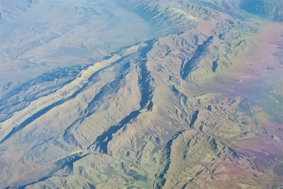
The San Andreas Fault is perhaps the most famous earthquake fault globally, running approximately 800 miles through California and marking the boundary between the Pacific Plate and the North American Plate. Despite its celebrity status, the public familiarity with its name has not translated into a realistic understanding of what a major rupture would mean. A 2025 California Earthquake Authority study found that nearly two out of every five residents of the state live within 10 miles of an active fault, highlighting the interconnectedness of the region’s seismic danger.
A 2024 USGS report emphasizes that California’s earthquake risk is a complex fault network, where secondary faults like Hayward and Calaveras could interact with the San Andreas itself, with stress modeling showing that a rupture on one fault could trigger movement on adjacent faults, potentially resulting in a cascade of earthquakes much larger than a single event. The sheer scale of interconnected risk here is something most residents simply do not factor into their daily lives.
The Hayward Fault, San Francisco Bay Area
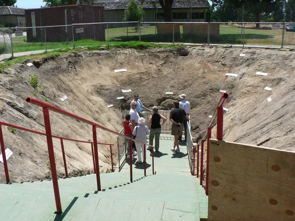
The Hayward Fault is a right-lateral strike-slip fault running through the densely populated East Bay, through Oakland, Berkeley, and Hayward. It last ruptured in 1868 and is considered one of the most dangerous urban faults in the country. What makes it particularly troubling is not just its location, but its track record of silence. The U.S. Geological Survey estimates a roughly one-in-three chance of a magnitude 6.7 or larger event occurring before 2043, making the Hayward Fault the most dangerous in the Bay Area.
Over two million people live on or immediately adjacent to the Hayward Fault, according to 2025 census updates, with hospitals, schools, and bridges, many built before seismic retrofitting was standard, all at high risk. A 2024 review of East Bay public schools found that nearly half still lacked full seismic upgrades. The fault runs directly beneath university campuses, sports stadiums, and water supply infrastructure. In a real sense, the built environment here was designed around the assumption that a big quake wouldn’t happen on anyone’s watch.
The Cascadia Subduction Zone, Pacific Northwest

The Cascadia Subduction Zone is a roughly 700-mile offshore megathrust running from Northern California to British Columbia, capable of producing magnitude 9 earthquakes. Its last full rupture was in 1700. That silence is not reassurance. It means strain has been building for more than 300 years. The Cascadia megathrust is comprised of at least four segments, the most dangerous of which appears to sit off the coast of Washington State and south Vancouver Island, where the eastward-moving Juan de Fuca plate slides under the North American plate.
Most subduction zones have lots of small earthquakes occurring all the time, giving scientists a lot of information about fault geometry, but Cascadia is eerily quiet in terms of seismicity. That quiet is what makes it so deceptive to live near. The survey also revealed small faults close to the coast which could potentially slip and generate tsunami waves, and if these nearshore faults slipped alongside a megathrust earthquake farther offshore, the resulting tsunami could hit the beach much sooner than expected.
The Seattle Fault Zone, Washington State
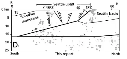
New research suggests Seattle earthquake faults may pose greater risks than previously believed, especially from hidden underground fault lines beneath the city, with scientists warning that shallow earthquakes in the Seattle Fault Zone could produce intense shaking in densely populated areas. The Seattle Fault Zone stretches east-west beneath the Seattle metropolitan area and across parts of Puget Sound, and researchers have known about the main fault for decades, but recent studies suggest the underground network may be more extensive than once believed.
Evidence shows the Seattle earthquake faults have produced major earthquakes in the past, with geological records pointing to a powerful earthquake around the year 923 CE that dramatically reshaped parts of the region. Of all 50 states in the U.S., Washington has one of the highest risks of large and damaging earthquakes because of its geologic setting and population distribution. Yet many residents think of Seattle’s seismic hazard as something subordinate to the famous Cascadia fault offshore, when the threat directly beneath the city may demand equal attention.
The New Madrid Seismic Zone, Central United States

Historical records show that the 1811 to 1812 New Madrid sequence produced quakes estimated between magnitude 7.0 and 8.0, shaking cities as far as Washington, D.C. and ringing church bells in Boston. Today, the USGS places the odds of a magnitude 6.0 or higher event in this area at roughly one in fourteen within the next 50 years. That might sound reassuring until you consider what is sitting on top of this fault system now. The same fault system that produced those three powerful earthquakes in 1811 to 1812 today threatens an estimated 15 million largely unprepared people, with cities at risk including Memphis, St. Louis, Nashville, Evansville, Little Rock, and Paducah.
Most buildings in the region predate modern seismic codes, and a 2024 report from the Central U.S. Earthquake Consortium warns that a repeat of the 19th-century quakes could leave three million people without power and cause roughly $300 billion in infrastructure losses. State transportation agencies report that nearly three out of every five major bridges along the Mississippi River corridor would be compromised in a magnitude 7.0 event. This is a region that still does not culturally associate itself with earthquake risk, which is precisely what makes it so vulnerable.
The North Anatolian Fault, Turkey
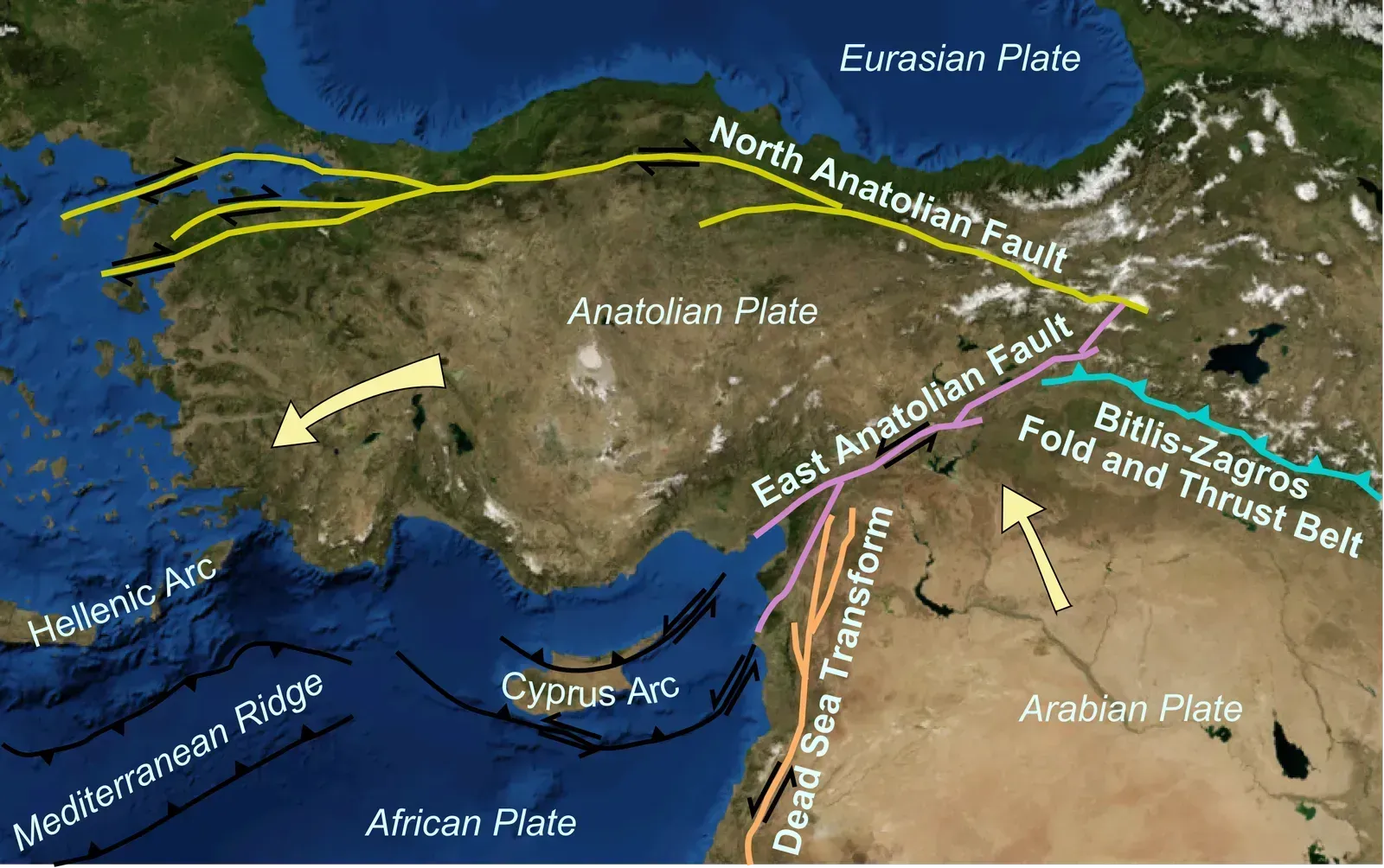
The North Anatolian Fault stretches for around 1,500 kilometres from east to west, crossing the whole of Anatolia, and is a classic example of a strike-slip fault where two blocks of crust slide horizontally. It is famous for the chain of powerful earthquakes that seem to propagate along its length, a phenomenon seismologists sometimes call a seismic cascade, and the 1999 earthquake in Izmit, which killed more than 17,000 people, was a stark reminder of just how dangerous this fault line is.
The proximity of Istanbul, a city with a population of over 15 million, raises the stakes even higher, and scientists are using GPS networks and seismic stations to measure accumulated stresses in the crust and better understand when and where the next earthquake might occur. On February 6, 2023, a magnitude 7.8 earthquake struck Turkey and Syria, killing more than 50,000 people, a sobering reminder that even in a country that knows its seismic history, the toll can be catastrophic when infrastructure and preparedness fall short.
The Himalayan Frontal Thrust, India and Nepal
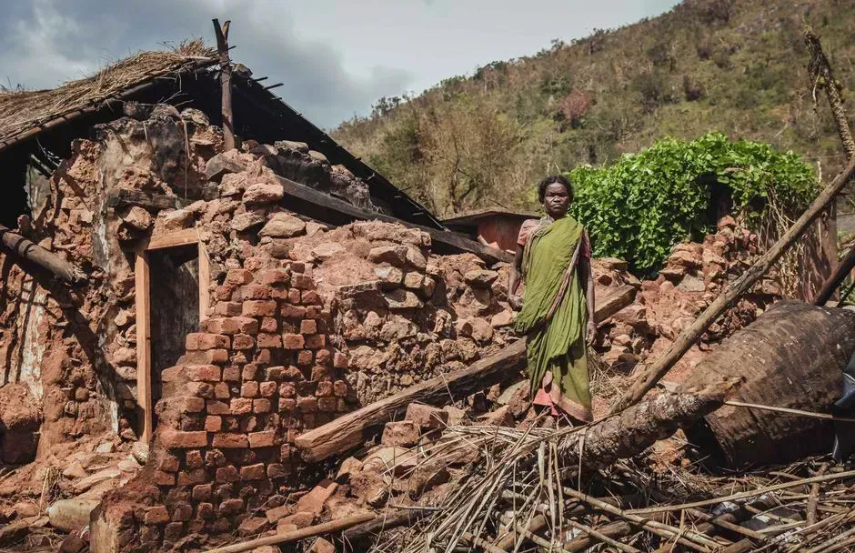
The Main Himalayan Thrust serves as the primary plate boundary fault where the Indian and Eurasian collision occurs, with the two plates remaining locked together in many areas, accumulating tectonic strain over centuries. When enough stress builds up, these locked sections suddenly release their energy, producing large earthquakes that can affect millions of people across the densely populated foothills and valleys. Recent scientific research has identified four sections of the 2,000-kilometer-long Himalayan arc most likely to unleash destructive earthquakes, with many parts showing no major surface ruptures for 200 to 700 years, suggesting that significant seismic events may be overdue.
Almost the entire Himalayan arc has now been placed in the newly created Zone VI, the highest seismic hazard category, in the map released under the Earthquake Design Code 2025 by India’s Bureau of Indian Standards. The updated map also shows that over three out of five percent of the country is in moderate to high risk zones. Some segments of the Central Himalaya, particularly between Uttarakhand and western Nepal, haven’t had a major quake in almost 200 years, a long gap that indicates strain has been building across this part of the arc. The scale of the exposed population here is simply without parallel anywhere else on earth.
The Wasatch Fault, Utah

About 240 miles long, Utah’s Wasatch Fault stretches along the western edge of the Wasatch Mountains from southern Idaho to central Utah, running through Salt Lake City and the state’s other population centers, and it is a seismically active normal fault that has moved many times in the past. In terms of annualized earthquake loss and casualties, Utah has the fourth-highest seismic risk among U.S. states, after California, Washington, and Oregon, with seismic hazard highest in the urban corridor along the Wasatch fault zone, which has hosted at least 24 surface-rupturing earthquakes of magnitude 6.75 or greater in the last 6,500 years.
About 85 percent of Utah’s residents, infrastructure, and economy are concentrated within 15 miles of the state’s most active fault, the Wasatch fault, making the Wasatch Front the highest risk area in the state. The Wasatch Fault, though steep at the surface, curves to a shallower angle at depth, increasing the potential for strong surface shaking during earthquakes, and fault rocks are significantly weaker and more prone to slip due to ancient and repeated deformation, making communities along the fault more vulnerable than previously thought. For a state that rarely makes national earthquake headlines, that concentration of exposure is remarkable.
The Alpine Fault, New Zealand
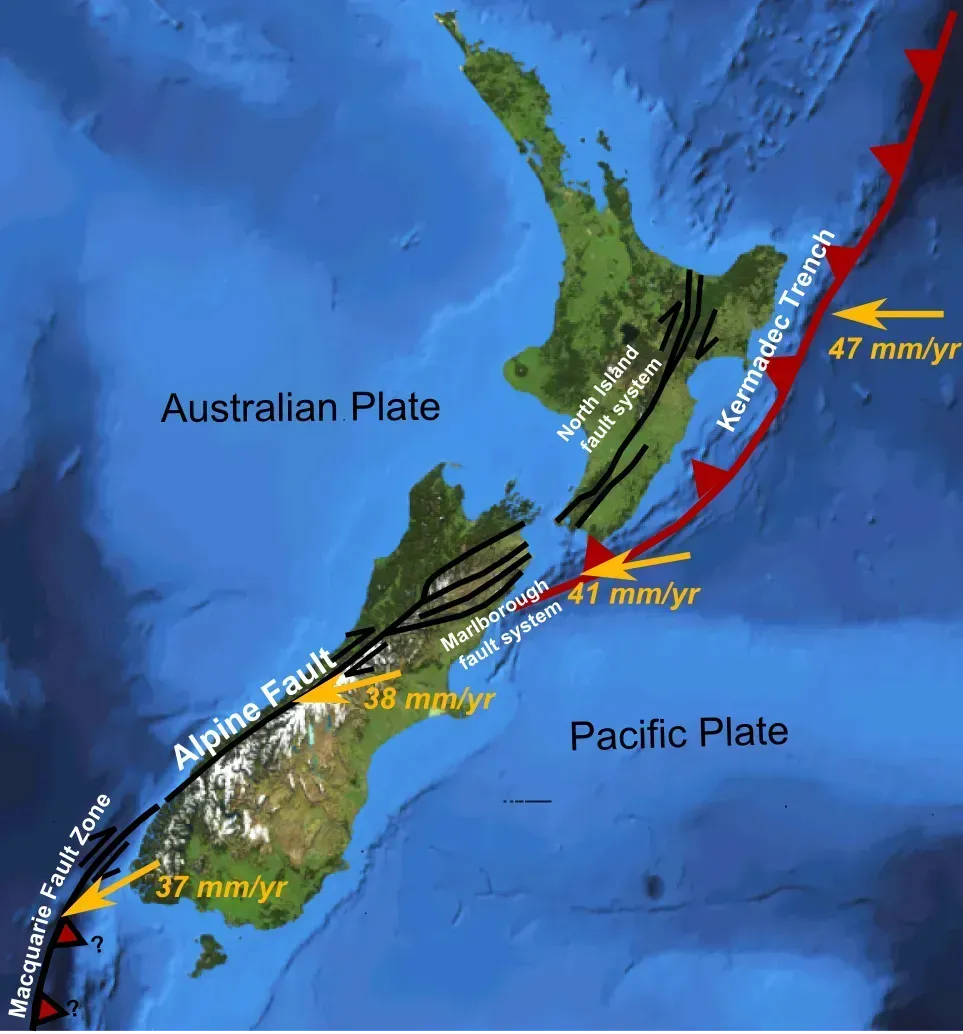
The Alpine Fault is famous in geological circles for its unusually regular major earthquakes, which occur roughly every 250 to 300 years with magnitudes near 8. The last rupture in 1717 was so powerful that Māori oral histories describe rivers changing course and slopes collapsing across entire valleys. That means it has been accumulating stress for over 300 years, putting it well within the window of a potential major rupture. It is a strike-slip fault that accommodates the horizontal motion between the Pacific Plate and the Indo-Australian Plate, and it poses a significant seismic risk to the South Island of New Zealand.
Scientists drill deep cores to study thousands of years of past earthquakes, discovering remarkably consistent patterns that help predict future seismic hazards. New Zealand’s South Island depends on infrastructure, including roads and bridges, that runs directly across or near the fault trace. A full rupture would not just shake cities; it would isolate communities across the island for potentially weeks or months. The regularity of this fault’s behavior is both its most useful scientific feature and its most sobering fact.
The Sagaing Fault, Myanmar
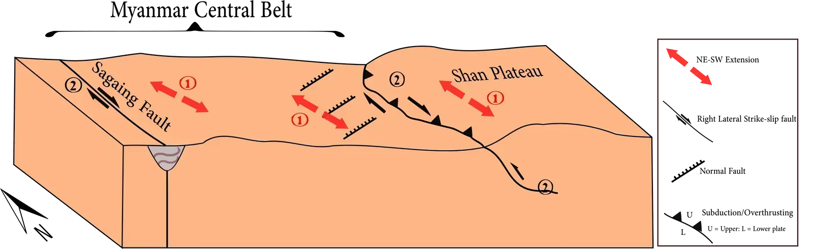
The powerful earthquake that struck Myanmar on March 28, 2025, gave researchers an uncommon chance to observe how some of the planet’s most dangerous fault systems behave. The earthquake occurred along an unusually straight and geologically mature fault, creating nearly ideal conditions to examine how energy is released during a major continental rupture. The magnitude 7.7 Mandalay earthquake caused widespread and severe damage in Myanmar and neighboring countries such as Thailand, with more than 5,000 casualties.
The 2025 Mandalay event contrasted sharply with many recent earthquakes where surface motion was reduced because energy spread across networks of small fractures. On the Sagaing Fault, energy was highly focused and came right to the surface, which means the ground shaking near the fault line may be more intense than current hazard models predict for these types of faults. That finding has implications well beyond Myanmar. Millions of people live in cities that sit atop geologically mature faults worldwide, and the assumption that surface shaking would be moderated may need serious revision across the board.

- The Shoreline Sucked Dry in Seconds – 5 Tsunami Signals Beachgoers Mistake for Low Tide - November 14, 2026
- 9 Dark-Sky Destinations Around the World Where the Stars Look Unreal - November 14, 2026
- The Fault Line That Never Slips – 7 Locked Seismic Zones Overdue for a Massive Release - November 14, 2026
